Fitxategi:Greece in 1210.svg

SVG fitxategi honen PNG aurreikuspenaren tamaina: 800 × 456 pixel. Bestelako bereizmenak: 320 × 182 pixel | 640 × 365 pixel | 1.024 × 584 pixel | 1.280 × 730 pixel | 2.560 × 1.460 pixel | 3.508 × 2.000 pixel.
Bereizmen handikoa (SVG fitxategia, nominaldi 3.508 × 2.000 pixel, fitxategiaren tamaina: 1,12 MB)
Fitxategi hau Wikimedia Commonsekoa da. Hango deskribapen orriko informazioa behean duzu. |
Laburpena
| Deskribapena |
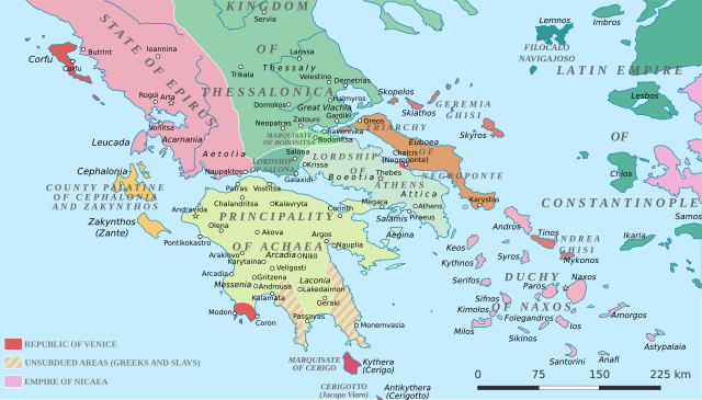
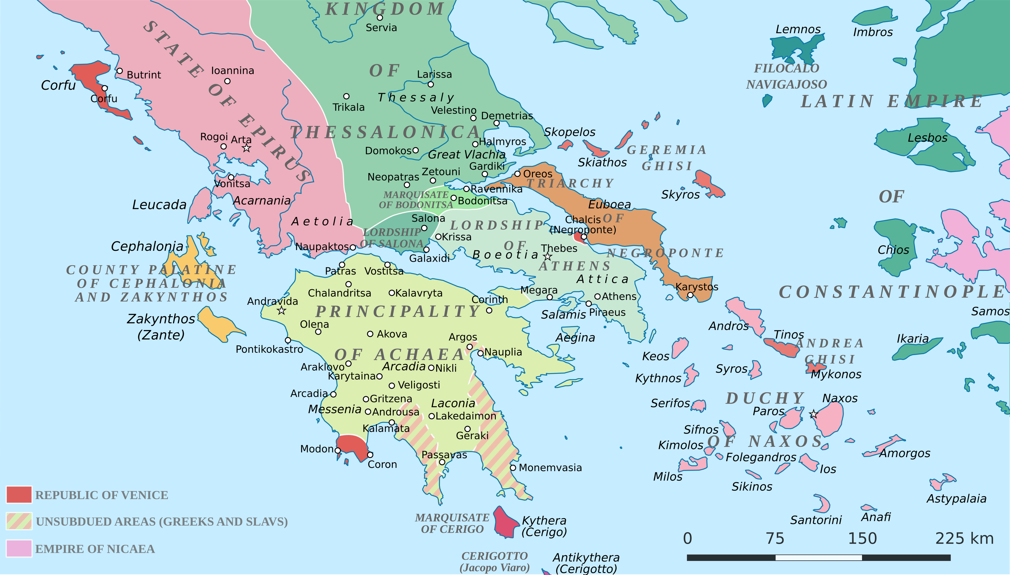
English: Political map of southern Greece in c. 1210, after the establishment of the Crusader states following the Fourth Crusade. |
| Data | |
| Jatorria |
SVG base from File:Greece in 1210V1.svg; based on the original political map by William Miller (1908), with changes and corrections to account for newer scholarship:
|
| Egilea | Cplakidas |
| Beste bertsioak |
|


Lizentzia
Nik, lan honen egileak, argitaratzen dut ondorengo lizentzia pean:
This file is licensed under the Creative Commons Attribution-Share Alike 4.0 International license.
- Askea zara:
- partekatzeko – lana kopiatzeko, banatzeko eta bidaltzeko
- birnahasteko – lana moldatzeko
- Ondorengo baldintzen pean:
- eskuduntza – Egiletza behar bezala aitortu behar duzu, lizentzia ikusteko esteka gehitu, eta ea aldaketak egin diren aipatu. Era egokian egin behar duzu hori guztia, baina inola ere ez egileak zure lana edo zure erabilera babesten duela irudikatuz.
- berdin partekatu – Lan honetan oinarrituta edo aldatuta berria eraikitzen baduzu, emaitza lana hau bezalako lizentzia batekin argitaratu behar duzu.
Fitxategiaren historia
Data/orduan klik egin fitxategiak orduan zuen itxura ikusteko.
| Data/Ordua | Iruditxoa | Neurriak | Erabiltzailea | Iruzkina | |
|---|---|---|---|---|---|
| oraingoa | 21:59, 23 ekaina 2017 | | 3.508 × 2.000 (1,12 MB) | Cplakidas | fixed three names to paths |
| 14:08, 11 apirila 2017 |  | 3.508 × 2.000 (1,1 MB) | Cplakidas | colour changes | |
| 13:48, 11 apirila 2017 |  | 3.508 × 2.000 (1,11 MB) | Cplakidas | tweak around Coron | |
| 12:39, 11 otsaila 2017 |  | 3.508 × 2.000 (1,11 MB) | Cplakidas | tweaks in Negroponte, unsubdued areas | |
| 19:57, 8 otsaila 2017 |  | 3.508 × 2.000 (1,11 MB) | Cplakidas | tweaking the Morea | |
| 15:40, 8 otsaila 2017 |  | 3.508 × 2.000 (1,11 MB) | Cplakidas | slight tweaks | |
| 15:14, 8 otsaila 2017 |  | 3.508 × 2.000 (1,11 MB) | Cplakidas | User created page with UploadWizard |
Irudira dakarten loturak
Hurrengo orrialdeek dute fitxategi honetarako lotura:
Fitxategiaren erabilera orokorra
Hurrengo beste wikiek fitxategi hau darabilte:
- ar.wikipedia.org proiektuan duen erabilera
- az.wikipedia.org proiektuan duen erabilera
- bg.wikipedia.org proiektuan duen erabilera
- ca.wikipedia.org proiektuan duen erabilera
- da.wikipedia.org proiektuan duen erabilera
- de.wikipedia.org proiektuan duen erabilera
- el.wikipedia.org proiektuan duen erabilera
- en.wikipedia.org proiektuan duen erabilera
- eo.wikipedia.org proiektuan duen erabilera
- fa.wikipedia.org proiektuan duen erabilera
- fr.wikipedia.org proiektuan duen erabilera
- gl.wikipedia.org proiektuan duen erabilera
- hr.wikipedia.org proiektuan duen erabilera
- id.wikipedia.org proiektuan duen erabilera
- it.wikipedia.org proiektuan duen erabilera
- ja.wikipedia.org proiektuan duen erabilera
- ko.wikipedia.org proiektuan duen erabilera
- ro.wikipedia.org proiektuan duen erabilera
- ru.wikipedia.org proiektuan duen erabilera
- sk.wikipedia.org proiektuan duen erabilera
- sr.wikipedia.org proiektuan duen erabilera
Ikus fitxategi honen erabilpen global gehiago.