Fitxategi:Grampound - geograph.org.uk - 198301.jpg
Ez dago bereizmen handiagorik.
Grampound_-_geograph.org.uk_-_198301.jpg ((640 × 427 pixel, fitxategiaren tamaina: 104 KB, MIME mota: image/jpeg))
Fitxategi hau Wikimedia Commonsekoa da. Hango deskribapen orriko informazioa behean duzu. |
Laburpena
| Deskribapena |
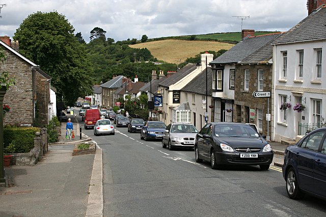
English: Grampound with Creed lies in the centre of Cornwall, sheltered in the beautiful valley of the River Fal. Settled since prehistoric times, from within the ancient parish of Creed and the old manor of Tybesta, Grampound grew as the main crossing place on the Fal, a focus for travellers and traders moving betwen west Cornwall and England. Thus Grampound became one of the most important towns in Cornwall with a rich and vibrant history. The main A390 road now runs through the town, bringing with it the problems of traffic, but Grampound remains a beautiful location with a rich community life and spirit. |
| Data | |
| Jatorria | From geograph.org.uk |
| Egilea | Tony Atkin |
| Aitortu (required by the license) | Tony Atkin / Grampound / |
| Kameraren kokapena | | Irudi hau eta gehiago beraien kokapenekin hurrengo lekuetan: OpenStreetMap |
|---|
_heading:292.00&language=eu)
| Objektuaren kokapena | | Irudi hau eta gehiago beraien kokapenekin hurrengo lekuetan: OpenStreetMap |
|---|
_heading:292.00&language=eu)
Lizentzia

|
This image was taken from the Geograph project collection. See this photograph's page on the Geograph website for the photographer's contact details. The copyright on this image is owned by Tony Atkin and is licensed for reuse under the Creative Commons Attribution-ShareAlike 2.0 license.
|
This file is licensed under the Creative Commons Attribution-Share Alike 2.0 Generic license.
Aitortu: Tony Atkin
- Askea zara:
- partekatzeko – lana kopiatzeko, banatzeko eta bidaltzeko
- birnahasteko – lana moldatzeko
- Ondorengo baldintzen pean:
- eskuduntza – Egiletza behar bezala aitortu behar duzu, lizentzia ikusteko esteka gehitu, eta ea aldaketak egin diren aipatu. Era egokian egin behar duzu hori guztia, baina inola ere ez egileak zure lana edo zure erabilera babesten duela irudikatuz.
- berdin partekatu – Lan honetan oinarrituta edo aldatuta berria eraikitzen baduzu, emaitza lana hau bezalako lizentzia batekin argitaratu behar duzu.
Fitxategiaren historia
Data/orduan klik egin fitxategiak orduan zuen itxura ikusteko.
| Data/Ordua | Iruditxoa | Neurriak | Erabiltzailea | Iruzkina | |
|---|---|---|---|---|---|
| oraingoa | 18:41, 31 urtarrila 2010 | | 640 × 427 (104 KB) | GeographBot | == {{int:filedesc}} == {{Information |description={{en|1=Grampound. The village of Grampound seems to have one overriding characteristic which you notice before anything else - traffic.}} |date=2006-07-08 |source=From [http://www.geograph.org.uk/photo/198 |
Irudira dakarten loturak
Hurrengo orrialdeek dute fitxategi honetarako lotura:
Fitxategiaren erabilera orokorra
Hurrengo beste wikiek fitxategi hau darabilte: