Fitxategi:Geographical and Magnetic Poles.png

Aurreikuspen honen neurria: 668 × 599 pixel. Bestelako bereizmenak: 268 × 240 pixel | 535 × 480 pixel | 856 × 768 pixel | 1.028 × 922 pixel.
Bereizmen handikoa ((1.028 × 922 pixel, fitxategiaren tamaina: 174 KB, MIME mota: image/png))
Fitxategi hau Wikimedia Commonsekoa da. Hango deskribapen orriko informazioa behean duzu. |
תרשים סכמטי של כדור הארץ
- A = ציר הסיבוב של כדור הארץ (מסומן בקו ירוק)
- A1 A2 = הקטבים הגאוגרפיים - הנקודות שבהן "חותך" ציר הסיבוב את פני כדור הארץ.
- הגלעין החיצוני (נוזלי) (מסומן בצבע אפור) - שכבה בכדור הארץ שבה נוצר השדה המגנטי, על פי w:he:תאוריית הדינמו.
- B = ציר הדו-קוטביות (מסומן בקו כחול) - הציר המגנטי הדו-קוטבי, המדמה מעין מוט מגנטי, שחלקו הצפוני הוא מגנט שמבחינה פיזיקלית נחשב ל"דרומי" (מסומן ב-S = South = דרום), ואילו חלקו הדרומי נחשב ל"צפוני" (N = North = צפון) מבחינה פיזיקלית. כיום, הזווית בין ציר זה לבין ציר הסיבוב של כדור הארץ היא 11.3°.
- B1 B2 = הקטבים הגאומגנטיים - הנקודות שבהן "חותך" ציר הדו-קוטביות את פני כדור הארץ.
- קווי השדה המגנטי (קווים שחורים דקים) - מתארים את כיוון השדה המגנטי מחוץ לגלעין.
- C1 C2 = הקטבים המגנטיים - הנקודות שבהן קווי השדה המגנטי (מסומנים בקווים שחורים) מאונכים לפני כדור הארץ (זווית של 90° בדיוק בגובה פני הקרקע). הקטבים המגנטיים אינם חופפים לקטבים הגאומגנטיים.
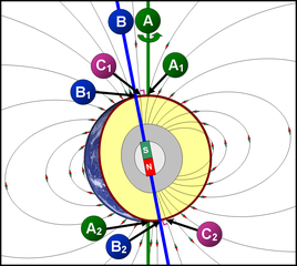
Schematic diagram of the Earth
- A = Earth's axis of rotation (marked with a green line)
- A1 A2 = the geographical poles - the points at which the axis of rotation "cuts" the axis of rotation of the earth.
- The outer core (liquid) (marked in gray) - a layer on Earth where the magnetic field is formed, according to the dynamo theory.
- B = Bipolar Axis (marked with a blue line) - The bipolar magnetic axis, which simulates a kind of magnetic rod, the northern part of which is a magnet that is physically considered "southern" (marked with S = South = South), while its southern part Is considered "North" (N = North = North) physically. Today, the angle between this axis and the axis of rotation of the Earth is 11.3 °.
- B1 B2 = the geomagnetic poles - the points at which the bipolar axis "cuts" the earth's surface.
- Magnetic field lines (thin black lines) - describe the direction of the magnetic field outside the nucleus.
- C1 C2 = The magnetic poles - the points at which the magnetic field lines (marked with black lines) are perpendicular to the Earth (an angle of 90 ° exactly at ground level). The magnetic poles do not overlap with the geomagnetic poles.
Laburpena
| Deskribapena | A=Geographic poles, B=Geomagnetic poles, C=Magnetic poles |
| Data | |
| Jatorria | Norberak egina |
| Egilea | DMY |
Lizentzia
Nik, lan honen egileak, argitaratzen dut ondorengo lizentzia hauen pean:

|
Baimena duzu dokumentu hau kopiatu, banatu edo/eta aldatzeko GNU Free Documentation License baldintzapean, Free Software Foundationek argitaratutako 1.2 edo ondorengo bertsioan; sekzio aldaezinik gabe, azaleko testurik gabe, eta atzeko azaleko testurik gabe. Lizentziaren kopia dago GNU Free Documentation License izenburudun atalean. |
Fitxategi hau Creative Commons Aitortu 3.0 Unported lizentziaren mende dago.
- Askea zara:
- partekatzeko – lana kopiatzeko, banatzeko eta bidaltzeko
- birnahasteko – lana moldatzeko
- Ondorengo baldintzen pean:
- eskuduntza – Egiletza behar bezala aitortu behar duzu, lizentzia ikusteko esteka gehitu, eta ea aldaketak egin diren aipatu. Era egokian egin behar duzu hori guztia, baina inola ere ez egileak zure lana edo zure erabilera babesten duela irudikatuz.
Nahiago duzun lizentzia erabil dezakezu.
Fitxategiaren historia
Data/orduan klik egin fitxategiak orduan zuen itxura ikusteko.
| Data/Ordua | Iruditxoa | Neurriak | Erabiltzailea | Iruzkina | |
|---|---|---|---|---|---|
| oraingoa | 11:11, 13 azaroa 2007 | | 1.028 × 922 (174 KB) | DMY | |
| 22:43, 11 azaroa 2007 |  | 1.028 × 922 (211 KB) | DMY | ||
| 22:23, 11 azaroa 2007 |  | 1.018 × 912 (210 KB) | DMY | == Summary == {{Information |Description=A=Geographic poles, B=Geomagnetic poles, C=Magnetic poles |Source=self-made |Date=Nov 3, 2007 |Author= DMY |Permission= |other_versions= }} == Licensing == {{self|GFDL|cc-by-3.0}} |
Irudira dakarten loturak
Hurrengo orrialdeek dute fitxategi honetarako lotura:
Fitxategiaren erabilera orokorra
Hurrengo beste wikiek fitxategi hau darabilte:
- ar.wikipedia.org proiektuan duen erabilera
- ast.wikipedia.org proiektuan duen erabilera
- bn.wikipedia.org proiektuan duen erabilera
- ca.wikipedia.org proiektuan duen erabilera
- cs.wikipedia.org proiektuan duen erabilera
- cy.wikipedia.org proiektuan duen erabilera
- el.wikipedia.org proiektuan duen erabilera
- en.wikipedia.org proiektuan duen erabilera
- en.wikibooks.org proiektuan duen erabilera
- fr.wikipedia.org proiektuan duen erabilera
- he.wikipedia.org proiektuan duen erabilera
- ht.wikipedia.org proiektuan duen erabilera
- it.wikipedia.org proiektuan duen erabilera
- ja.wikipedia.org proiektuan duen erabilera
- ko.wikipedia.org proiektuan duen erabilera
- mk.wikipedia.org proiektuan duen erabilera
- ms.wikipedia.org proiektuan duen erabilera
- ne.wikipedia.org proiektuan duen erabilera
- nl.wikipedia.org proiektuan duen erabilera
- nl.wikibooks.org proiektuan duen erabilera
- pl.wikipedia.org proiektuan duen erabilera
- pt.wikipedia.org proiektuan duen erabilera
- simple.wikipedia.org proiektuan duen erabilera
- sr.wikipedia.org proiektuan duen erabilera
- uz.wikipedia.org proiektuan duen erabilera
- vi.wikipedia.org proiektuan duen erabilera
- www.wikidata.org proiektuan duen erabilera