Fitxategi:Gavialis gangeticus.jpg
Aurreikuspen honen neurria: 800 × 533 pixel. Bestelako bereizmenak: 320 × 213 pixel | 640 × 427 pixel | 1.024 × 682 pixel | 1.280 × 853 pixel.
Bereizmen handikoa ((1.280 × 853 pixel, fitxategiaren tamaina: 994 KB, MIME mota: image/jpeg))
Fitxategi hau Wikimedia Commonsekoa da. Hango deskribapen orriko informazioa behean duzu. |
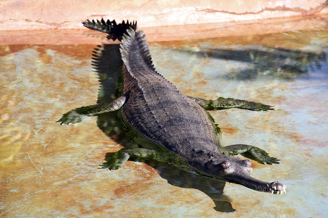
| Deskribapena | The Gharial is uniformly dark olive-gray with a pale yellow belly. Juveniles have dark spots and cross bands against a light background. Gharials have an extremely elongated snout. The teeth are needle-like and the eyes green frosted with back. A large male can reach 23 feet in length, and a female 15 feet. Gharials, being the most aquatic of all crocodilians, are awkward out of water mainly due to their short stumpy legs. The adult male develops a pot-like structure on the end of the snout, giving the gharial its name from "ghara" -- Hindi for earthen pot. This nose knob is used to produce a bussing noise that repels rival males and serves as an audible warning system. | ||
| Data | |||
| Jatorria | originally posted to Flickr as Gharial (Gavialis gangeticus) | ||
| Egilea | Cliff | ||
| Lizentzia (Fitxategi hau berrerabiltzen) |
Fitxategi hau Creative Commons Aitorpena 2.0 Generikoa lizentziapean dago.
|
| Kameraren kokapena | | Irudi hau eta gehiago beraien kokapenekin hurrengo lekuetan: OpenStreetMap |
|---|
Fitxategiaren historia
Data/orduan klik egin fitxategiak orduan zuen itxura ikusteko.
| Data/Ordua | Iruditxoa | Neurriak | Erabiltzailea | Iruzkina | |
|---|---|---|---|---|---|
| oraingoa | 08:40, 28 urtarrila 2018 | | 1.280 × 853 (994 KB) | Archaeodontosaurus | Corrections |
| 13:48, 10 martxoa 2012 |  | 1.280 × 853 (380 KB) | Egg | Reverted to version as of 23:26, 27 September 2008 | |
| 13:45, 10 martxoa 2012 |  | 4.005 × 2.316 (3,57 MB) | Egg | ||
| 01:26, 28 iraila 2008 |  | 1.280 × 853 (380 KB) | Flickr upload bot | Uploaded from http://flickr.com/photo/28567825@N03/2854165521 using Flickr upload bot |
Irudira dakarten loturak
Hurrengo orrialdeek dute fitxategi honetarako lotura:
Fitxategiaren erabilera orokorra
Hurrengo beste wikiek fitxategi hau darabilte:
- azb.wikipedia.org proiektuan duen erabilera
- az.wikipedia.org proiektuan duen erabilera
- be.wikipedia.org proiektuan duen erabilera
- br.wikipedia.org proiektuan duen erabilera
- br.wiktionary.org proiektuan duen erabilera
- cv.wikipedia.org proiektuan duen erabilera
- el.wikipedia.org proiektuan duen erabilera
- en.wikipedia.org proiektuan duen erabilera
- eo.wikipedia.org proiektuan duen erabilera
- fa.wikipedia.org proiektuan duen erabilera
- gl.wikipedia.org proiektuan duen erabilera
- gu.wikipedia.org proiektuan duen erabilera
- he.wikipedia.org proiektuan duen erabilera
- תניניים
- אליגטוריים
- אליגטור
- אליגטור אמריקני
- אליגטור סיני
- קיימן (סוג)
- קיימן שחור
- קיימן גמדי
- קיימן גמדי של קיווייה
- קיימן גמדי של שניידר
- תנין (סוג)
- תנין גמדי
- גוויאליים
- גוויאל הודי
- גוויאל חקיין
- תנין הים
- תנין היאור
- תנינאים
- קיימן ממושקף
- קיימן רחב-חרטום
- קיימן ז'קרה
- תנין אורינוקו
- תנין אמריקאי
- תנין הביצות
- תנין קובני
- תבנית:תנינאים
- תנין מורלט
- תנין צר-חרטום מערב-אפריקני
- תנין מערב-אפריקני
- תנין ג'ונסטון
- תנין גינאה החדשה
- תנין פיליפיני
- תנין סיאמי
- תנין צר-חרטום
- קיימנים
- תנין צר-חרטום מרכז-אפריקני
- תנין האלי
Ikus fitxategi honen erabilpen global gehiago.