Fitxategi:Franco-Cantabrian region.gif

Aurreikuspen honen neurria: 800 × 403 pixel. Bestelako bereizmenak: 320 × 161 pixel | 640 × 323 pixel | 956 × 482 pixel.
Bereizmen handikoa ((956 × 482 pixel, fitxategiaren tamaina: 21 KB, MIME mota: image/gif))
Fitxategi hau Wikimedia Commonsekoa da. Hango deskribapen orriko informazioa behean duzu. |
Laburpena
| Deskribapena |
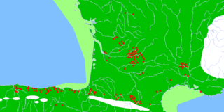
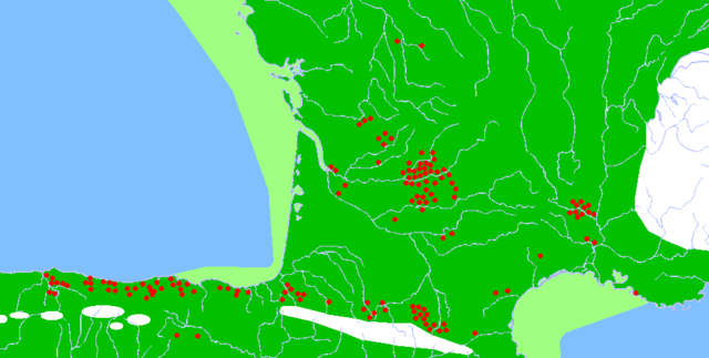
Description: Map of the Franco-Cantabrian archaeological region (Upper Paleolithic), showing:
|
| Data | |
| Jatorria |
|
| Egilea |
|
| Lizentzia (Fitxategi hau berrerabiltzen) |
Released into the public domain (by the author). |
| Beste bertsioak | Derivative works of this file: Franco-Cantabrian region Altamira.gif |
Lizentzia
| |
This work has been released into the public domain by its author, Sugaar, at the ingelesa Wikipedia project. This applies worldwide. In case this is not legally possible: |
| Annotations | This image is annotated: View the annotations at Commons |
Fitxategiaren historia
Data/orduan klik egin fitxategiak orduan zuen itxura ikusteko.
| Data/Ordua | Iruditxoa | Neurriak | Erabiltzailea | Iruzkina | |
|---|---|---|---|---|---|
| oraingoa | 22:17, 13 otsaila 2007 | | 956 × 482 (21 KB) | Theklan | {{Information |Description= Description: Map of the Franco-Cantabrian archaeological region (Upper Paleolithic), showing: * Main caves with mural art (red dots) * Approximate extension of permanent ice (white) * Approximate extension of now submerged land |
Irudira dakarten loturak
Hurrengo orrialdeek dute fitxategi honetarako lotura:
Fitxategiaren erabilera orokorra
Hurrengo beste wikiek fitxategi hau darabilte:
- ar.wikipedia.org proiektuan duen erabilera
- arz.wikipedia.org proiektuan duen erabilera
- bn.wikipedia.org proiektuan duen erabilera
- ca.wikipedia.org proiektuan duen erabilera
- da.wikipedia.org proiektuan duen erabilera
- da.wikibooks.org proiektuan duen erabilera
- de.wikipedia.org proiektuan duen erabilera
- en.wikipedia.org proiektuan duen erabilera
- es.wikipedia.org proiektuan duen erabilera
- eu.wikibooks.org proiektuan duen erabilera
- fi.wikipedia.org proiektuan duen erabilera
- fr.wikipedia.org proiektuan duen erabilera
- he.wikipedia.org proiektuan duen erabilera
- hr.wikipedia.org proiektuan duen erabilera
- it.wikipedia.org proiektuan duen erabilera
- ja.wikipedia.org proiektuan duen erabilera
- no.wikipedia.org proiektuan duen erabilera
- oc.wikipedia.org proiektuan duen erabilera
- ru.wikipedia.org proiektuan duen erabilera
- sh.wikipedia.org proiektuan duen erabilera
- sl.wikipedia.org proiektuan duen erabilera
- tr.wikipedia.org proiektuan duen erabilera
- uk.wikipedia.org proiektuan duen erabilera
- www.wikidata.org proiektuan duen erabilera
- zh.wikipedia.org proiektuan duen erabilera