Fitxategi:First ETR in China.svg

SVG fitxategi honen PNG aurreikuspenaren tamaina: 705 × 599 pixel. Bestelako bereizmenak: 282 × 240 pixel | 565 × 480 pixel | 904 × 768 pixel | 1.205 × 1.024 pixel | 2.409 × 2.048 pixel | 1.000 × 850 pixel.
Bereizmen handikoa (SVG fitxategia, nominaldi 1.000 × 850 pixel, fitxategiaren tamaina: 232 KB)
Fitxategi hau Wikimedia Commonsekoa da. Hango deskribapen orriko informazioa behean duzu. |
Laburpena
| Deskribapena |
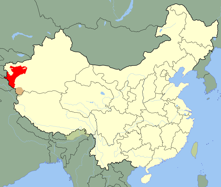
A SVG map of China with Xinjiang's Kashgar Prefecture highlighted in red; the modern-day district in which the w:en:First East Turkestan Republic was located. Legend: |
||
| Data | (UTC) | ||
| Jatorria | |||
| Egilea |
|
||
| SVG genesis | Fitxategi hau (bektore-irudia) hau Inkscape-ekin sortu da .
|
.svg)
| This is a retouched picture, which means that it has been digitally altered from its original version. Modifications: Unhighlighted Xinjiang as a whole, removed sub-provincial markers. The original can be viewed here: China Xinjiang Kashgar.svg:
|
Lizentzia
Nik, lan honen egileak, argitaratzen dut ondorengo lizentzia pean:
| Nik, lan honen egile eskubideen jabeak, lan hau domeinu publikoan jartzen dut. Mundu osoan du eragina honek. Estatu batzuetan beharbada hori ez da legez posible izango. Halakoetan: Edonori ematen diot lan hau edozertarako erabiltzeko eskubidea, inolako baldintzarik gabe, legeak nahitaez ezarritako baldintzak izan ezik. |
Jatorrizko igoera erregistroa
This image is a derivative work of the following images:
- File:China_Xinjiang_Kashgar.svg licensed with PD-self
- 2010-02-12T14:52:39Z Joowwww 1000x850 (237684 Bytes) {{Information |Description=An SVG map of China with Xinjiang highlighted in orange and Kashgar Prefecture highlighted in red Legend:[[:File:China map legend.png]] |Source=self-made; based on CIA public domain maps: *http://w
Uploaded with derivativeFX
Fitxategiaren historia
Data/orduan klik egin fitxategiak orduan zuen itxura ikusteko.
| Data/Ordua | Iruditxoa | Neurriak | Erabiltzailea | Iruzkina | |
|---|---|---|---|---|---|
| oraingoa | 23:10, 24 maiatza 2020 | | 1.000 × 850 (232 KB) | Roy17 | Reverted to version as of 23:09, 18 August 2010 (UTC) |
| 04:39, 24 maiatza 2020 |  | 1.000 × 810 (249 KB) | Anchuhu | Reverted to version as of 12:39, 19 January 2019 (UTC) roc borders isn’t like China now | |
| 03:43, 12 martxoa 2020 |  | 1.000 × 850 (232 KB) | Jonteemil | Reverted to version as of 23:09, 18 August 2010 (UTC) | |
| 14:39, 19 urtarrila 2019 |  | 1.000 × 810 (249 KB) | 复旦大学张超 | edit | |
| 01:09, 19 abuztua 2010 |  | 1.000 × 850 (232 KB) | Splittist | {{Information |Description=A SVG map of China with Xinjiang's Kashgar Prefecture highlighted in red; the modern-day district in which the w:en:First East Turkestan Republic was located. Legend:<br />File:China map legend.png |Source=*[[:File:China |
Irudira dakarten loturak
Hurrengo orrialdeek dute fitxategi honetarako lotura:
Fitxategiaren erabilera orokorra
Hurrengo beste wikiek fitxategi hau darabilte:
- ar.wikipedia.org proiektuan duen erabilera
- azb.wikipedia.org proiektuan duen erabilera
- az.wikipedia.org proiektuan duen erabilera
- bn.wikipedia.org proiektuan duen erabilera
- de.wikipedia.org proiektuan duen erabilera
- en.wikipedia.org proiektuan duen erabilera
- es.wikipedia.org proiektuan duen erabilera
- fa.wikipedia.org proiektuan duen erabilera
- fr.wikipedia.org proiektuan duen erabilera
- id.wikipedia.org proiektuan duen erabilera
- incubator.wikimedia.org proiektuan duen erabilera
- it.wikipedia.org proiektuan duen erabilera
- ja.wikipedia.org proiektuan duen erabilera
- ko.wikipedia.org proiektuan duen erabilera
- lv.wikipedia.org proiektuan duen erabilera
- nl.wikipedia.org proiektuan duen erabilera
- nn.wikipedia.org proiektuan duen erabilera
- pl.wikipedia.org proiektuan duen erabilera
- pnb.wikipedia.org proiektuan duen erabilera
- pt.wikipedia.org proiektuan duen erabilera
- ru.wikipedia.org proiektuan duen erabilera
- sr.wikipedia.org proiektuan duen erabilera
- th.wikipedia.org proiektuan duen erabilera
- tr.wikipedia.org proiektuan duen erabilera
Ikus fitxategi honen erabilpen global gehiago.