Fitxategi:Federal subjects of Russia by population dencity.svg

SVG fitxategi honen PNG aurreikuspenaren tamaina: 800 × 434 pixel. Bestelako bereizmenak: 320 × 173 pixel | 640 × 347 pixel | 1.024 × 555 pixel | 1.280 × 694 pixel | 2.560 × 1.388 pixel | 5.000 × 2.710 pixel.
Bereizmen handikoa (SVG fitxategia, nominaldi 5.000 × 2.710 pixel, fitxategiaren tamaina: 240 KB)
Fitxategi hau Wikimedia Commonsekoa da. Hango deskribapen orriko informazioa behean duzu. |
Crimea is Ukraine

|
The boundaries on this map show the de facto situation. This is just one of several different views on the subject (see COM:NPOV). |
Laburpena
| Deskribapena |
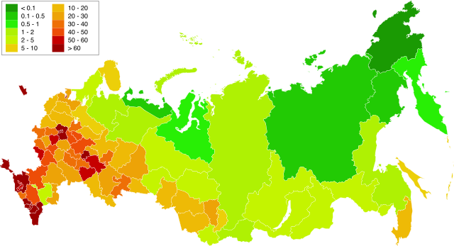
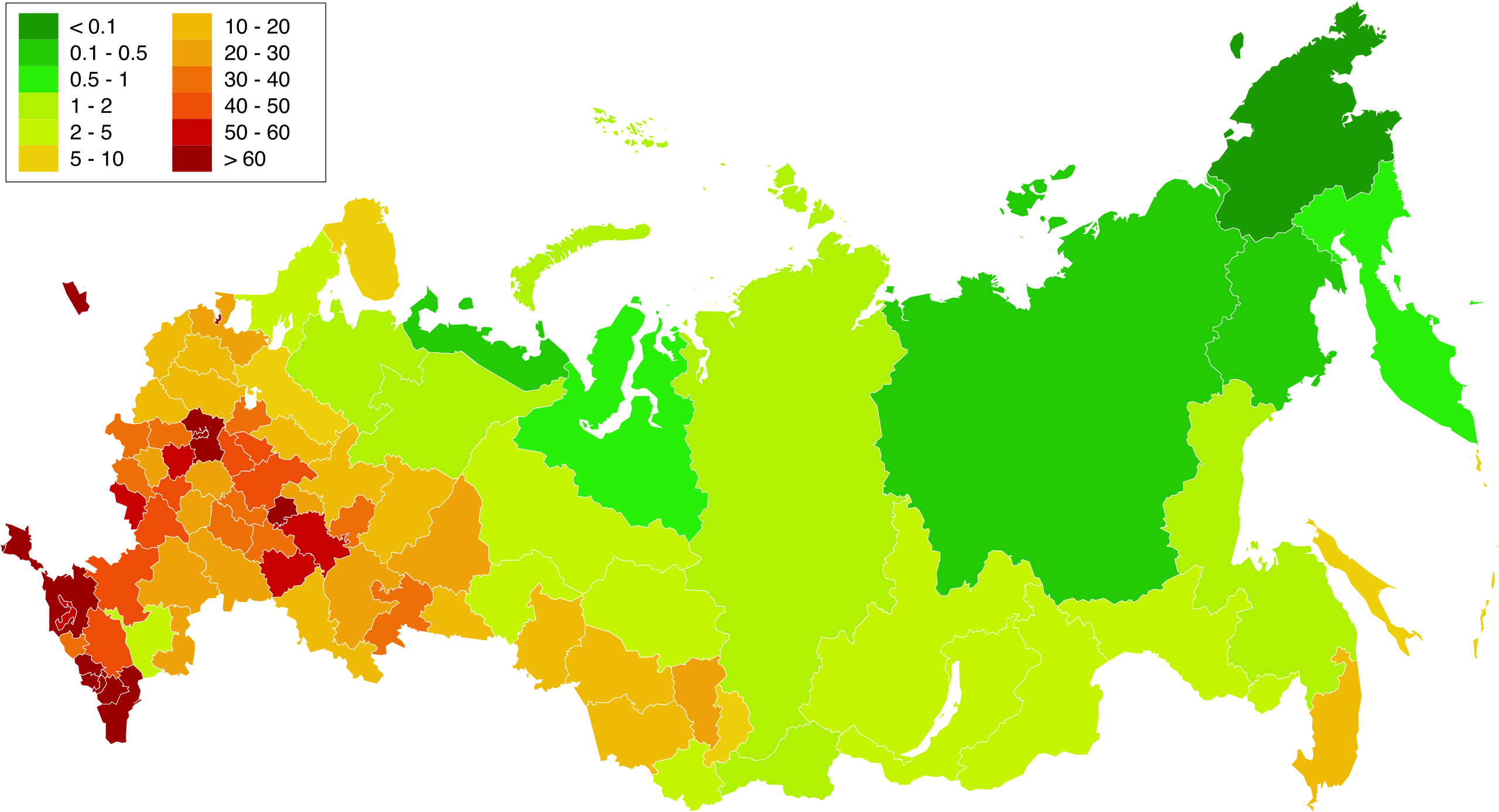
English: Map of population density in the subjects of the Russian Federation. The population density of Arkhangelsk Oblast and Tyumen Oblast was calculated together with the population and area of the respective Autonomous Okrugs belonging to them.
Русский: Карта плотности населения в субъектах Российской Федерации. При расчёте плотностей населения Архангельской и Тюменской области учитывались площади и населения входящих в них автономных округов. |
| Data | 1.02.2010 20:39:08 MSK |
| Jatorria | Russia - blank map (2009-01).svg |
| Egilea | Norberak egina. Original uploader was Алексей Глушков at ru.wikipedia |
| Beste bertsioak |
Other views related to this image
|

.svg)
Lizentzia
| Nik, lan honen egile eskubideen jabeak, lan hau domeinu publikoan jartzen dut. Mundu osoan du eragina honek. Estatu batzuetan beharbada hori ez da legez posible izango. Halakoetan: Edonori ematen diot lan hau edozertarako erabiltzeko eskubidea, inolako baldintzarik gabe, legeak nahitaez ezarritako baldintzak izan ezik. |
Fitxategiaren historia
Data/orduan klik egin fitxategiak orduan zuen itxura ikusteko.
| Data/Ordua | Iruditxoa | Neurriak | Erabiltzailea | Iruzkina | |
|---|---|---|---|---|---|
| oraingoa | 18:58, 20 martxoa 2019 | | 5.000 × 2.710 (240 KB) | Gajmar | Kaluga Oblast |
| 22:46, 19 martxoa 2019 |  | 5.000 × 2.710 (240 KB) | Gajmar | new colour scheme | |
| 22:17, 19 martxoa 2019 |  | 5.000 × 2.710 (236 KB) | Gajmar | update (01.01.2019) | |
| 17:39, 3 martxoa 2013 |  | 1.650 × 1.000 (141 KB) | Gajmar | 1.01.2013 | |
| 18:53, 28 maiatza 2011 |  | 1.650 × 1.000 (140 KB) | Gajmar | Update the data according to Russian census of 2010 (as of October 14). Indications of population density changed in Karachay-Cherkess Republic, Republic of Mari El, Leningrad Oblast and the Jewish Autonomous Oblast. / Обновление данных с | |
| 20:22, 1 otsaila 2010 |  | 1.650 × 1.000 (109 KB) | Алексей Глушков | {{Information |Description={{en|1=Population density map in subjects of the Russian Federation. At calculation of population density Arkhangelsk and the Tyumen region the areas and the population of autonomous regions entering into them were considered.}} |
Irudira dakarten loturak
Hurrengo orrialdeek dute fitxategi honetarako lotura:
Fitxategiaren erabilera orokorra
Hurrengo beste wikiek fitxategi hau darabilte:
- af.wikipedia.org proiektuan duen erabilera
- ar.wikipedia.org proiektuan duen erabilera
- az.wikipedia.org proiektuan duen erabilera
- bg.wikipedia.org proiektuan duen erabilera
- de.wikipedia.org proiektuan duen erabilera
- es.wikipedia.org proiektuan duen erabilera
- fa.wikipedia.org proiektuan duen erabilera
- hu.wikipedia.org proiektuan duen erabilera
- kk.wikipedia.org proiektuan duen erabilera
- pnb.wikipedia.org proiektuan duen erabilera
- ps.wikipedia.org proiektuan duen erabilera
- ru.wikipedia.org proiektuan duen erabilera
- te.wikipedia.org proiektuan duen erabilera
- zh.wikipedia.org proiektuan duen erabilera