Fitxategi:Falkirk, The Steeple - geograph.org.uk - 1540536.jpg

Bereizmen handikoa ((480 × 640 pixel, fitxategiaren tamaina: 150 KB, MIME mota: image/jpeg))
Fitxategi hau Wikimedia Commonsekoa da. Hango deskribapen orriko informazioa behean duzu. |
Laburpena
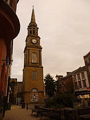
| Deskribapena |
English: Falkirk: The Steeple The Steeple stands alongside the Market Place on the High Street and is the third to occupy the site. The first was a 16th or 7th century structure which was demolished in 1697 having become unsafe. The second suffered from serious subsidence after its foundations became damaged it was demmolished in 1803.
The current structure cost £1,460 to erect in 1814. It was designed by David Hamilton and built by Hanry Taylor using sandstone from the quarry at nearby Brightons. It is 140 feet high and, at ground level, is 22 feet square, and has not been without further difficulties: The upper 40 feet of the tower were replaced after being struck by lightning in June 1927. A horse belonging to Barr & Co., aerated water manufacturers, was killed by the falling masonry and its driver injured. The town jail was once housed within The Steeple, and two cells on the upper floors, accessed by a narrow spiral staircase, survive. |
| Data | |
| Jatorria | From geograph.org.uk |
| Egilea | Chris Downer |
| Aitortu (required by the license) | Chris Downer / Falkirk: The Steeple / |
| Kameraren kokapena | | Irudi hau eta gehiago beraien kokapenekin hurrengo lekuetan: OpenStreetMap |
|---|
_heading:135.00&language=eu)
| Objektuaren kokapena | | Irudi hau eta gehiago beraien kokapenekin hurrengo lekuetan: OpenStreetMap |
|---|
_heading:135.00&language=eu)
Lizentzia

|
This image was taken from the Geograph project collection. See this photograph's page on the Geograph website for the photographer's contact details. The copyright on this image is owned by Chris Downer and is licensed for reuse under the Creative Commons Attribution-ShareAlike 2.0 license.
|
- Askea zara:
- partekatzeko – lana kopiatzeko, banatzeko eta bidaltzeko
- birnahasteko – lana moldatzeko
- Ondorengo baldintzen pean:
- eskuduntza – Egiletza behar bezala aitortu behar duzu, lizentzia ikusteko esteka gehitu, eta ea aldaketak egin diren aipatu. Era egokian egin behar duzu hori guztia, baina inola ere ez egileak zure lana edo zure erabilera babesten duela irudikatuz.
- berdin partekatu – Lan honetan oinarrituta edo aldatuta berria eraikitzen baduzu, emaitza lana hau bezalako lizentzia batekin argitaratu behar duzu.
Fitxategiaren historia
Data/orduan klik egin fitxategiak orduan zuen itxura ikusteko.
| Data/Ordua | Iruditxoa | Neurriak | Erabiltzailea | Iruzkina | |
|---|---|---|---|---|---|
| oraingoa | 11:38, 3 martxoa 2011 | | 480 × 640 (150 KB) | GeographBot | == {{int:filedesc}} == {{Information |description={{en|1=Falkirk: The Steeple The Steeple stands alongside the Market Place on the High Street and is the third to occupy the site. The first was a 16th or 7th century structure which was demolished in 1697 |
Irudira dakarten loturak
Hurrengo orrialdeek dute fitxategi honetarako lotura:
Fitxategiaren erabilera orokorra
Hurrengo beste wikiek fitxategi hau darabilte:
- de.wikipedia.org proiektuan duen erabilera