Fitxategi:Europe HSR density1.svg

SVG fitxategi honen PNG aurreikuspenaren tamaina: 800 × 557 pixel. Bestelako bereizmenak: 320 × 223 pixel | 640 × 445 pixel | 1.024 × 712 pixel | 1.280 × 890 pixel | 2.560 × 1.781 pixel | 1.150 × 800 pixel.
Bereizmen handikoa (SVG fitxategia, nominaldi 1.150 × 800 pixel, fitxategiaren tamaina: 729 KB)
Fitxategi hau Wikimedia Commonsekoa da. Hango deskribapen orriko informazioa behean duzu. |
Laburpena
| Deskribapena |
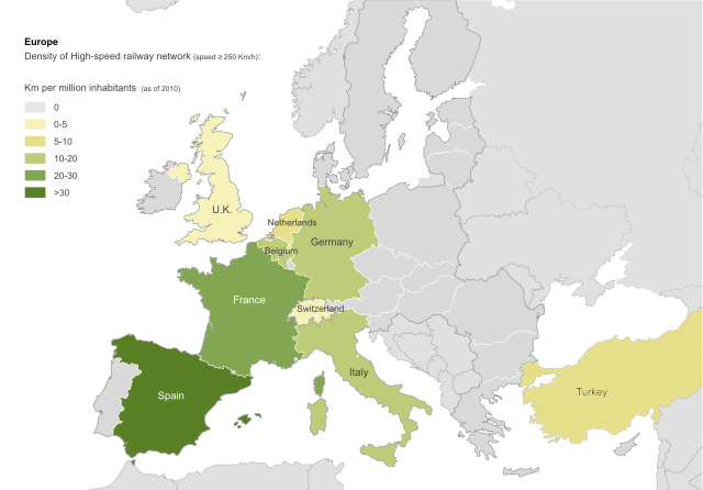
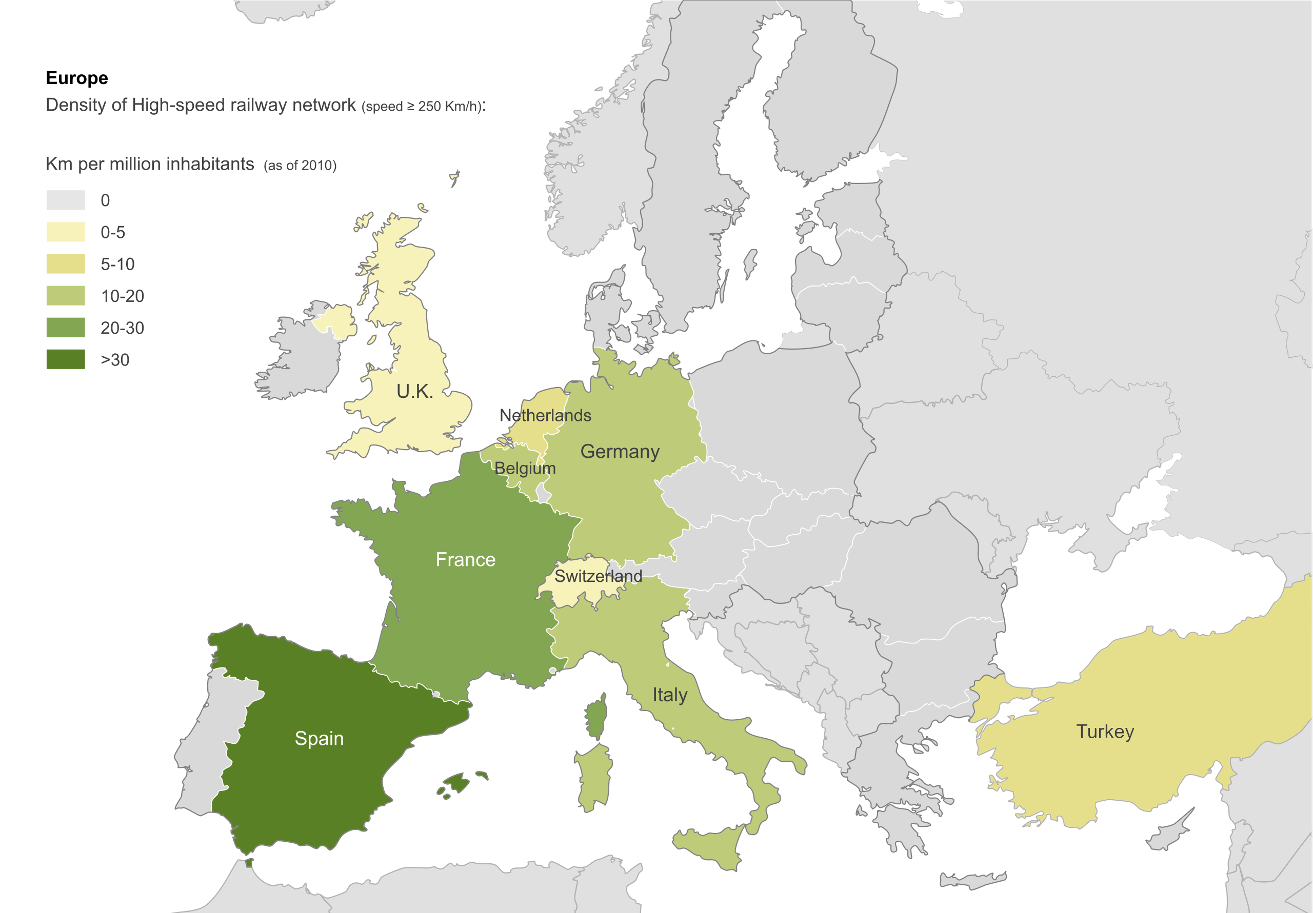
Density of High-speed railway network in Europe (speed ≥ 250 Km/h). Km per million inhabitants (as of 2010). |
| Data | |
| Jatorria | own work on File:Blank_map_of_Europe.svg |
| Egilea | Antschaser |
| Beste bertsioak | Español: File: Europa densidad alta velocidad.svg; Français: File:Europe densité LGV.svg |
Lizentzia
Nik, lan honen egileak, argitaratzen dut ondorengo lizentzia hauen pean:

|
Baimena duzu dokumentu hau kopiatu, banatu edo/eta aldatzeko GNU Free Documentation License baldintzapean, Free Software Foundationek argitaratutako 1.2 edo ondorengo bertsioan; sekzio aldaezinik gabe, azaleko testurik gabe, eta atzeko azaleko testurik gabe. Lizentziaren kopia dago GNU Free Documentation License izenburudun atalean. |
This file is licensed under the Creative Commons Attribution-Share Alike 4.0 International, 3.0 Unported, 2.5 Generic, 2.0 Generic and 1.0 Generic license.
- Askea zara:
- partekatzeko – lana kopiatzeko, banatzeko eta bidaltzeko
- birnahasteko – lana moldatzeko
- Ondorengo baldintzen pean:
- eskuduntza – Egiletza behar bezala aitortu behar duzu, lizentzia ikusteko esteka gehitu, eta ea aldaketak egin diren aipatu. Era egokian egin behar duzu hori guztia, baina inola ere ez egileak zure lana edo zure erabilera babesten duela irudikatuz.
- berdin partekatu – Lan honetan oinarrituta edo aldatuta berria eraikitzen baduzu, emaitza lana hau bezalako lizentzia batekin argitaratu behar duzu.
Nahiago duzun lizentzia erabil dezakezu.
Fitxategiaren historia
Data/orduan klik egin fitxategiak orduan zuen itxura ikusteko.
| Data/Ordua | Iruditxoa | Neurriak | Erabiltzailea | Iruzkina | |
|---|---|---|---|---|---|
| oraingoa | 22:33, 31 uztaila 2012 | | 1.150 × 800 (729 KB) | Antschaser | Reverted to version as of 11:05, 9 September 2011: new countries added have not HSR over 250km, wich is the used criteria. If you change criteria, you should do another map adding lines with those characteristics for all the countries. |
| 14:36, 18 uztaila 2012 |  | 2.000 × 1.391 (755 KB) | Nicksss93 | Sweden added. | |
| 18:31, 16 uztaila 2012 |  | 2.000 × 1.391 (747 KB) | Nicksss93 | Kaliningrad added. | |
| 18:23, 16 uztaila 2012 |  | 2.000 × 1.391 (747 KB) | Nicksss93 | Map updated - Austria, Poland and Russia added. | |
| 19:50, 1 uztaila 2012 |  | 1.150 × 800 (261 KB) | Nicksss93 | Bulgaria added. | |
| 13:05, 9 iraila 2011 |  | 1.150 × 800 (729 KB) | Emturan | In Turkey, new lines open to revenue services. Total line lenght: 457 km, Population. 73.72 million. Density:6.2 | |
| 11:24, 9 iraila 2011 |  | 1.150 × 800 (624 KB) | Emturan | Reverted to version as of 18:51, 23 October 2010 | |
| 11:20, 9 iraila 2011 |  | 1.150 × 800 (624 KB) | Emturan | New lines open to revenue services. Total line lenght: 457 km, Population. 73.72 million | |
| 20:51, 23 urria 2010 |  | 1.150 × 800 (624 KB) | Antschaser | adding background | |
| 20:14, 23 urria 2010 |  | 1.150 × 800 (625 KB) | Antschaser | fonts |
Irudira dakarten loturak
Hurrengo orrialdeek dute fitxategi honetarako lotura:
Fitxategiaren erabilera orokorra
Hurrengo beste wikiek fitxategi hau darabilte:
- en.wikipedia.org proiektuan duen erabilera
- th.wikipedia.org proiektuan duen erabilera