Fitxategi:Egypt 1450 BC.svg

SVG fitxategi honen PNG aurreikuspenaren tamaina: 520 × 600 pixel. Bestelako bereizmenak: 208 × 240 pixel | 416 × 480 pixel | 666 × 768 pixel | 887 × 1.024 pixel | 1.775 × 2.048 pixel | 1.300 × 1.500 pixel.
Bereizmen handikoa (SVG fitxategia, nominaldi 1.300 × 1.500 pixel, fitxategiaren tamaina: 257 KB)
Fitxategi hau Wikimedia Commonsekoa da. Hango deskribapen orriko informazioa behean duzu. |
Laburpena
| Deskribapena |
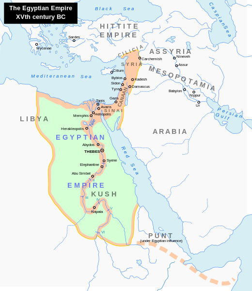
English: Map of the Middle East 1450 BC (by ArdadN)
Čeština: Největší územní rozsah starověkého Egypta, za vlády Thutmose I. |
| Jatorria |
The original description page was here. All following user names refer to en.wikipedia.
|
| Egilea | ArdadN at ingelesa Wikipedia |
| Beste bertsioak |
[]
|


|
SVG fitxategi honek Inkscape edo Adobe Illustrator bezalako SVG editore bat erabiliz erraz itzul daitekeen barneratutako testua du. Argibide gehiago. Nahi izanez gero, fitxategia jaitsi eta testu editore bat erabiliz ere itzul dezakezu. |
Lizentzia
| Nik, lan honen egile eskubideen jabeak, lan hau domeinu publikoan jartzen dut. Mundu osoan du eragina honek. Estatu batzuetan beharbada hori ez da legez posible izango. Halakoetan: Edonori ematen diot lan hau edozertarako erabiltzeko eskubidea, inolako baldintzarik gabe, legeak nahitaez ezarritako baldintzak izan ezik. |
Fitxategiaren historia
Data/orduan klik egin fitxategiak orduan zuen itxura ikusteko.
| Data/Ordua | Iruditxoa | Neurriak | Erabiltzailea | Iruzkina | |
|---|---|---|---|---|---|
| oraingoa | 00:18, 24 iraila 2023 | | 1.300 × 1.500 (257 KB) | Gaaryeelidmaan | Punt was associated with Myrrh trade, a product found in modern Puntland https://www.worldhistory.org/punt/ |
| 07:28, 9 urria 2013 |  | 1.300 × 1.500 (257 KB) | Lymantria | Reverted to version as of 00:24, 10 August 2008 | |
| 18:05, 7 urria 2013 |  | 1.300 × 1.500 (238 KB) | Emara | تعريب الخريطة | |
| 02:24, 10 abuztua 2008 |  | 1.300 × 1.500 (257 KB) | Leoboudv | {{Information |Description=Map of the Middle East 1450 BC |Source=The original description page is/was [http://en.wikipedia.org/w/index.php?title=Image%3AEgypt_1450_BC.svg here]. All following user names refer to en.wikipedia. * 2008-05-07 09:18 [[:en:Use |
Irudira dakarten loturak
Hurrengo orrialdeek dute fitxategi honetarako lotura:
Fitxategiaren erabilera orokorra
Hurrengo beste wikiek fitxategi hau darabilte:
- ast.wikipedia.org proiektuan duen erabilera
- azb.wikipedia.org proiektuan duen erabilera
- az.wikipedia.org proiektuan duen erabilera
- ba.wikipedia.org proiektuan duen erabilera
- be.wikipedia.org proiektuan duen erabilera
- bg.wikipedia.org proiektuan duen erabilera
- bn.wikipedia.org proiektuan duen erabilera
- ca.wikipedia.org proiektuan duen erabilera
- cv.wikipedia.org proiektuan duen erabilera
- de.wikipedia.org proiektuan duen erabilera
- el.wikipedia.org proiektuan duen erabilera
- en.wikipedia.org proiektuan duen erabilera
- Timeline of Jerusalem
- Thutmose I
- The Bible Unearthed
- List of conflicts in Asia
- Middle Eastern empires
- List of conflicts in Egypt
- Land of Punt
- Transjordan (region)
- List of conflicts in Sudan
- List of conflicts in Libya
- User:Falcaorib
- Talk:The Exodus/Archive 18
- User:SomeGuyWhoRandomlyEdits/List of conflicts in the Near East
- fa.wikipedia.org proiektuan duen erabilera
- gl.wikipedia.org proiektuan duen erabilera
- hi.wikipedia.org proiektuan duen erabilera
- hy.wikipedia.org proiektuan duen erabilera
- hyw.wikipedia.org proiektuan duen erabilera
- id.wikipedia.org proiektuan duen erabilera
- id.wikibooks.org proiektuan duen erabilera
- is.wikipedia.org proiektuan duen erabilera
- it.wikipedia.org proiektuan duen erabilera
- ja.wikipedia.org proiektuan duen erabilera
Ikus fitxategi honen erabilpen global gehiago.