Fitxategi:Duchy of Prussia.svg

SVG fitxategi honen PNG aurreikuspenaren tamaina: 610 × 588 pixel. Bestelako bereizmenak: 249 × 240 pixel | 498 × 480 pixel | 797 × 768 pixel | 1.062 × 1.024 pixel | 2.125 × 2.048 pixel.
Bereizmen handikoa (SVG fitxategia, nominaldi 610 × 588 pixel, fitxategiaren tamaina: 55 KB)
Fitxategi hau Wikimedia Commonsekoa da. Hango deskribapen orriko informazioa behean duzu. |
Laburpena
| Deskribapena |
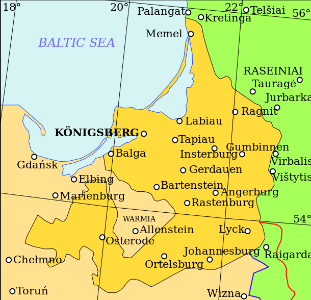
English: Map showing the Duchy of Prussia, at an indeterminable date. Place names inside the Duchy are given in German, as are Elbing and Marienburg. Other names are modern.
Territory of the Duchy of Prussia Territory of the Kingdom of Poland before the Union of Lublin Territory of the Grand Duchy of Lithuania before the Union of Lublin Polish-Lithuanian border before the Union of Lublin Polish-Lithuanian border after the Union of Lublin |
| Data | |
| Jatorria | Norberaren lana, ondorengo hau(ek) oinarri hartuta: (lituaniera) (2001) Lietuvos istorijos atlasas, Vilnius: Vaga, pp. 16—17 |
| Egilea | Grandiose |
| Beste bertsioak |
|
| SVG genesis | Fitxategi hau (bektore-irudia) hau Inkscape-ekin sortu da .
. |

| File | Type | Details |
|---|---|---|
| File:Polish-Lithuania map (1450-1600).svg | Large SVG | Map showing conflicts and territorial changes on the Polish-Lithuanian—Russian border, 1450–1600 |
| File:Duchy of Prussia.svg | Small SVG | Map of the Duchy of Prussia |
| File:Livonian war map (1558-1560).svg | Small SVG | Map showing campaigns in Livonia, 1558–1560. |
| File:Map of Poland and Lithuania after the Union of Lublin (1569).svg | Large SVG | Map of the w:Polish-Lithuanian Commonwealth after the Union of Lublin in 1569. |
| File:Livonian war map (1570-1577).svg | Small SVG | Map showing areas of Russian and Polish-Lithuanian forces, 1570–1577. |
| File:Campaigns of Stefan Batory.svg | Small SVG | Map of the campaign of Stefan Batory in Livonia (1575–1580). |
| File:Map of Poland and Lithuania in 1600.svg | Small SVG | Map of Livonia in 1600 |
| See also: User:Halibutt/maps, by Halibutt (eztabaida · ekarpenak). | ||
.svg)
.svg)
.svg)
.svg)
Lizentzia
Nik, lan honen egileak, argitaratzen dut ondorengo lizentzia pean:
Fitxategi hau Creative Commons Attribution-Share Alike 3.0 Unported lizentziapean dago.
- Askea zara:
- partekatzeko – lana kopiatzeko, banatzeko eta bidaltzeko
- birnahasteko – lana moldatzeko
- Ondorengo baldintzen pean:
- eskuduntza – Egiletza behar bezala aitortu behar duzu, lizentzia ikusteko esteka gehitu, eta ea aldaketak egin diren aipatu. Era egokian egin behar duzu hori guztia, baina inola ere ez egileak zure lana edo zure erabilera babesten duela irudikatuz.
- berdin partekatu – Lan honetan oinarrituta edo aldatuta berria eraikitzen baduzu, emaitza lana hau bezalako lizentzia batekin argitaratu behar duzu.
Fitxategiaren historia
Data/orduan klik egin fitxategiak orduan zuen itxura ikusteko.
| Data/Ordua | Iruditxoa | Neurriak | Erabiltzailea | Iruzkina | |
|---|---|---|---|---|---|
| oraingoa | 12:07, 20 apirila 2011 | | 610 × 588 (55 KB) | Grandiose | Correct spelling |
| 14:44, 19 apirila 2011 |  | 610 × 588 (54 KB) | Grandiose | Lines on longitude and latitude; other important fixes. | |
| 14:36, 19 apirila 2011 |  | 610 × 588 (1,1 MB) | Grandiose | Fix text locations | |
| 14:33, 19 apirila 2011 |  | 610 × 588 (1,1 MB) | Grandiose |
Irudira dakarten loturak
Hurrengo orrialdeek dute fitxategi honetarako lotura:
Fitxategiaren erabilera orokorra
Hurrengo beste wikiek fitxategi hau darabilte:
- ar.wikipedia.org proiektuan duen erabilera
- ast.wikipedia.org proiektuan duen erabilera
- br.wikipedia.org proiektuan duen erabilera
- ca.wikipedia.org proiektuan duen erabilera
- cs.wikipedia.org proiektuan duen erabilera
- de.wikipedia.org proiektuan duen erabilera
- el.wikipedia.org proiektuan duen erabilera
- en.wikipedia.org proiektuan duen erabilera
- fa.wikipedia.org proiektuan duen erabilera
- fi.wikipedia.org proiektuan duen erabilera
- gl.wikipedia.org proiektuan duen erabilera
- he.wikipedia.org proiektuan duen erabilera
- hr.wikipedia.org proiektuan duen erabilera
- hu.wikipedia.org proiektuan duen erabilera
- is.wikipedia.org proiektuan duen erabilera
- it.wikipedia.org proiektuan duen erabilera
- ja.wikipedia.org proiektuan duen erabilera
- ko.wikipedia.org proiektuan duen erabilera
- lt.wikipedia.org proiektuan duen erabilera
- mk.wikipedia.org proiektuan duen erabilera
- rue.wikipedia.org proiektuan duen erabilera
- ru.wikipedia.org proiektuan duen erabilera
- sc.wikipedia.org proiektuan duen erabilera
- sh.wikipedia.org proiektuan duen erabilera
- sv.wikipedia.org proiektuan duen erabilera
- th.wikipedia.org proiektuan duen erabilera
- tr.wikipedia.org proiektuan duen erabilera
- uk.wikipedia.org proiektuan duen erabilera
- vi.wikipedia.org proiektuan duen erabilera
- www.wikidata.org proiektuan duen erabilera
- zh.wikipedia.org proiektuan duen erabilera