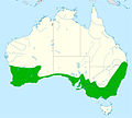
Fitxategi:Distribution red wattlebird.jpg

Aurreikuspen honen neurria: 667 × 599 pixel. Bestelako bereizmenak: 267 × 240 pixel | 534 × 480 pixel | 855 × 768 pixel | 1.140 × 1.024 pixel | 2.056 × 1.847 pixel.
Bereizmen handikoa ((2.056 × 1.847 pixel, fitxategiaren tamaina: 325 KB, MIME mota: image/jpeg))
Fitxategiaren historia
Data/orduan klik egin fitxategiak orduan zuen itxura ikusteko.
| Data/Ordua | Iruditxoa | Neurriak | Erabiltzailea | Iruzkina | |
|---|---|---|---|---|---|
| oraingoa | 12:48, 7 otsaila 2016 |  | 2.056 × 1.847 (325 KB) | Aa77zz | Expand range in arid area of southern WA south of Laverton based on Birddata. The low density of reported sightings makes it difficult to know where to draw the line. Also move boundary north of Murray River, the Victoria NSW boundary. Note that there... |
| 23:47, 6 otsaila 2016 |  | 2.056 × 1.847 (326 KB) | Aa77zz | Improved colouring | |
| 20:09, 6 otsaila 2016 |  | 2.056 × 1.847 (334 KB) | Aa77zz | User created page with UploadWizard |
Irudira dakarten loturak
Hurrengo orrialdeek dute fitxategi honetarako lotura:
Fitxategiaren erabilera orokorra
Hurrengo beste wikiek fitxategi hau darabilte:
- ar.wikipedia.org proiektuan duen erabilera
- arz.wikipedia.org proiektuan duen erabilera
- ast.wikipedia.org proiektuan duen erabilera
- bg.wikipedia.org proiektuan duen erabilera
- br.wikipedia.org proiektuan duen erabilera
- ca.wikipedia.org proiektuan duen erabilera
- ceb.wikipedia.org proiektuan duen erabilera
- cy.wikipedia.org proiektuan duen erabilera
- en.wikipedia.org proiektuan duen erabilera
- hu.wikipedia.org proiektuan duen erabilera
- nv.wikipedia.org proiektuan duen erabilera
- pl.wikipedia.org proiektuan duen erabilera
- sv.wikipedia.org proiektuan duen erabilera
- tr.wikipedia.org proiektuan duen erabilera
- uk.wikipedia.org proiektuan duen erabilera
- www.wikidata.org proiektuan duen erabilera
- zh.wikipedia.org proiektuan duen erabilera
