Fitxategi:Daito islands en.png

Aurreikuspen honen neurria: 800 × 485 pixel. Bestelako bereizmenak: 320 × 194 pixel | 640 × 388 pixel | 1.024 × 621 pixel | 1.458 × 884 pixel.
Bereizmen handikoa ((1.458 × 884 pixel, fitxategiaren tamaina: 324 KB, MIME mota: image/png))
Fitxategi hau Wikimedia Commonsekoa da. Hango deskribapen orriko informazioa behean duzu. |
Laburpena
| Deskribapena |
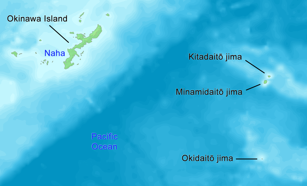
English: Map of Daito Islands (in English).
日本語: 大東諸島の地図(英語)。 |
||||
| Data | |||||
| Jatorria | http://www.demis.nl/wms/mapclip.htm | ||||
| Egilea | Tdk | ||||
| Lizentzia (Fitxategi hau berrerabiltzen) |
|
Lizentzia
| Nik, lan honen egile eskubideen jabeak, lan hau domeinu publikoan jartzen dut. Mundu osoan du eragina honek. Estatu batzuetan beharbada hori ez da legez posible izango. Halakoetan: Edonori ematen diot lan hau edozertarako erabiltzeko eskubidea, inolako baldintzarik gabe, legeak nahitaez ezarritako baldintzak izan ezik. |
Fitxategiaren historia
Data/orduan klik egin fitxategiak orduan zuen itxura ikusteko.
| Data/Ordua | Iruditxoa | Neurriak | Erabiltzailea | Iruzkina | |
|---|---|---|---|---|---|
| oraingoa | 16:58, 14 urria 2019 | | 1.458 × 884 (324 KB) | Artanisen | {{en|English: High quality map of the Daito Islands. Created with DEMIS World Map Server.}} {{ja|日本語:高品質の地図、大東諸島。}} |
| 05:58, 8 ekaina 2008 |  | 615 × 461 (87 KB) | Tdk~commonswiki | {{Information |Description={{en|1=Map of Daito Islands.(in English)}} {{ja|1=大東諸島の地図。(英語)}} |Source=http://www.demis.nl/wms/mapclip.htm |Author=Tdk |Date=2008/6/8 |Permission={{demis-pd}} |other_versions= }} {{ImageUpload|full}} |
Irudira dakarten loturak
Hurrengo orrialdeek dute fitxategi honetarako lotura:
Fitxategiaren erabilera orokorra
Hurrengo beste wikiek fitxategi hau darabilte:
- az.wikipedia.org proiektuan duen erabilera
- cs.wikipedia.org proiektuan duen erabilera
- de.wikipedia.org proiektuan duen erabilera
- en.wikipedia.org proiektuan duen erabilera
- es.wikipedia.org proiektuan duen erabilera
- fi.wikipedia.org proiektuan duen erabilera
- fr.wikipedia.org proiektuan duen erabilera
- it.wikipedia.org proiektuan duen erabilera
- ko.wikipedia.org proiektuan duen erabilera
- lt.wikipedia.org proiektuan duen erabilera
- no.wikipedia.org proiektuan duen erabilera
- pl.wikipedia.org proiektuan duen erabilera
- pt.wikipedia.org proiektuan duen erabilera
- ru.wikipedia.org proiektuan duen erabilera
- sv.wikipedia.org proiektuan duen erabilera
- tr.wikipedia.org proiektuan duen erabilera
- uk.wikipedia.org proiektuan duen erabilera
- uz.wikipedia.org proiektuan duen erabilera
- vi.wikipedia.org proiektuan duen erabilera
- www.wikidata.org proiektuan duen erabilera
- zh-classical.wikipedia.org proiektuan duen erabilera
- zh-yue.wikipedia.org proiektuan duen erabilera