Fitxategi:Cleveland Ohio aerial view.jpg

Aurreikuspen honen neurria: 800 × 534 pixel. Bestelako bereizmenak: 320 × 214 pixel | 640 × 427 pixel | 1.024 × 683 pixel | 1.500 × 1.001 pixel.
Bereizmen handikoa ((1.500 × 1.001 pixel, fitxategiaren tamaina: 680 KB, MIME mota: image/jpeg))
Fitxategi hau Wikimedia Commonsekoa da. Hango deskribapen orriko informazioa behean duzu. |
Laburpena
| Deskribapena |
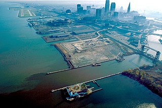
English: Aerial view of Cleveland, Ohio, USA, on the shores of Lake Erie. The mouth of the Cuyahoga River is visible in the foreground and Cleveland's Burke-Lakefront Airport is visible in the top left of the picture. View is to the northeast |
| Data | |
| Jatorria |
U.S. Army Corps of Engineers Digital Visual Library Image page Image description page Digital Visual Library home page |
| Egilea | Ken Winters, U.S. Army Corps of Engineers |
| Location | Cleveland, Ohio, USA |
| Kameraren kokapena | | Irudi hau eta gehiago beraien kokapenekin hurrengo lekuetan: OpenStreetMap |
|---|
Laburpena
This image or file is a work of a U.S. Army Corps of Engineers soldier or employee, taken or made as part of that person's official duties. As a work of the U.S. federal government, the image is in the public domain.
|
Fitxategiaren historia
Data/orduan klik egin fitxategiak orduan zuen itxura ikusteko.
| Data/Ordua | Iruditxoa | Neurriak | Erabiltzailea | Iruzkina | |
|---|---|---|---|---|---|
| oraingoa | 03:58, 25 martxoa 2007 | | 1.500 × 1.001 (680 KB) | DanMS | {{Information | Description = {{en|Aerial view of Cleveland, Ohio, USA, on the shores of Lake Erie. The mouth of the Cuyahoga River is visible in the foreground and Cleveland Airport is visible in the top left of the picture. View is to the northeast}} |
Irudira dakarten loturak
Hurrengo orrialdeek dute fitxategi honetarako lotura:
Fitxategiaren erabilera orokorra
Hurrengo beste wikiek fitxategi hau darabilte:
- de.wikivoyage.org proiektuan duen erabilera
- en.wikipedia.org proiektuan duen erabilera
- fr.wikipedia.org proiektuan duen erabilera
- it.wikipedia.org proiektuan duen erabilera
- ja.wikipedia.org proiektuan duen erabilera