Fitxategi:Canada provinces evolution 2.gif

Bereizmen handikoa ((1.000 × 864 pixel, fitxategiaren tamaina: 243 KB, MIME mota: image/gif), kiribildua, 20 irudi, 1m 13s)
Fitxategi hau Wikimedia Commonsekoa da. Hango deskribapen orriko informazioa behean duzu. |

|
This image could be re-created using vector graphics as an SVG file. This has several advantages; see Commons:Media for cleanup for more information. If an SVG form of this image is available, please upload it and afterwards replace this template with
{{vector version available|new image name}}.
It is recommended to name the SVG file "Canada provinces evolution 2.svg" - then the template Vector version available (or Vva) does not need the new image name parameter. |
|
Laburpena
| Deskribapena |
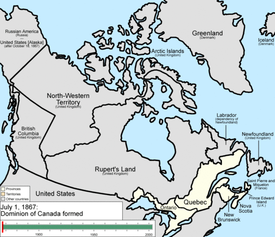
English: Animation of the changes to the borders of Canada.
The captions read as follows:
|
| Data | |
| Jatorria | Norberak egina |
| Egilea | Golbez |
Lizentzia
- Askea zara:
- partekatzeko – lana kopiatzeko, banatzeko eta bidaltzeko
- birnahasteko – lana moldatzeko
- Ondorengo baldintzen pean:
- eskuduntza – Egiletza behar bezala aitortu behar duzu, lizentzia ikusteko esteka gehitu, eta ea aldaketak egin diren aipatu. Era egokian egin behar duzu hori guztia, baina inola ere ez egileak zure lana edo zure erabilera babesten duela irudikatuz.
- berdin partekatu – Lan honetan oinarrituta edo aldatuta berria eraikitzen baduzu, emaitza lana hau bezalako lizentzia batekin argitaratu behar duzu.

|
Baimena duzu dokumentu hau kopiatu, banatu edo/eta aldatzeko GNU Free Documentation License baldintzapean, Free Software Foundationek argitaratutako 1.2 edo ondorengo bertsioan; sekzio aldaezinik gabe, azaleko testurik gabe, eta atzeko azaleko testurik gabe. Lizentziaren kopia dago GNU Free Documentation License izenburudun atalean. |
Fitxategiaren historia
Data/orduan klik egin fitxategiak orduan zuen itxura ikusteko.
| Data/Ordua | Iruditxoa | Neurriak | Erabiltzailea | Iruzkina | |
|---|---|---|---|---|---|
| oraingoa | 00:37, 15 uztaila 2009 | | 1.000 × 864 (243 KB) | Golbez | {{Information |Description=Animation of the changes to the borders of Canada. |Source=self-made |Date=July 15, 2009 |Author= Golbez |Permission= |other_versions= }} Category:Maps of the history of Canada Category:Animated GIF [[Ca |
Irudira dakarten loturak
Hurrengo orrialdeek dute fitxategi honetarako lotura:
Fitxategiaren erabilera orokorra
Hurrengo beste wikiek fitxategi hau darabilte:
- ar.wikipedia.org proiektuan duen erabilera
- be-tarask.wikipedia.org proiektuan duen erabilera
- bg.wikipedia.org proiektuan duen erabilera
- ca.wikipedia.org proiektuan duen erabilera
- ckb.wikipedia.org proiektuan duen erabilera
- cs.wikipedia.org proiektuan duen erabilera
- en.wikipedia.org proiektuan duen erabilera
- John A. Macdonald
- Manitoba
- Northwest Territories
- Ontario
- History of Canada
- Provinces and territories of Canada
- Talk:Labrador
- List of proposed provinces and territories of Canada
- Quebec Boundaries Extension Act, 1912
- History of Alberta
- Quebec Boundary Extension Act, 1898
- History of Western civilization
- Wikipedia:Featured pictures thumbs/06
- Canada
- Talk:Territorial evolution of Canada
- List of Canada-related topics by provinces and territories
- Demographics of the Northwest Territories
- Speaker of the Legislative Assembly of the Northwest Territories
- Portal:Canada/Selected picture
- Wikipedia:Featured pictures/Diagrams, drawings, and maps/Maps
- Wikipedia:Featured picture candidates/delist/2009
- Wikipedia:Featured picture candidates/delist/Canada provinces evolution.gif
- Talk:History of Canada/Archive 1
- Wikipedia:Featured picture candidates/November-2009
- Wikipedia:Featured picture candidates/Non-Native American Nations Control over N America 1750-2008.gif
- User:North8000
- User:Ezekiel11324/bordercity
- Former colonies and territories in Canada
- User:Soulscanner/Sandbox/CanHist
- Wikipedia:Reference desk/Archives/Miscellaneous/2011 August 15
- User talk:Golbez/Archive 6
- Template:POTD/2015-07-01
- Wikipedia:Picture of the day/July 2015
- Wikipedia:Main Page history/2015 July 1
- User:PMK2000/sandbox/Canada
- Timeline of Alberta history
- en.wikibooks.org proiektuan duen erabilera
- es.wikipedia.org proiektuan duen erabilera
Ikus fitxategi honen erabilpen global gehiago.