Fitxategi:Camargue map.png
Ez dago bereizmen handiagorik.
Camargue_map.png ((718 × 396 pixel, fitxategiaren tamaina: 42 KB, MIME mota: image/png))
Fitxategi hau Wikimedia Commonsekoa da. Hango deskribapen orriko informazioa behean duzu. |
Laburpena
| Deskribapena | ||||
| Data | ||||
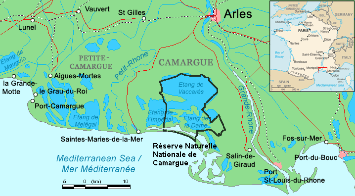
| Jatorria | Combination of CIA World Factbook map (Image:Fr-map.png) and Demis Map Server (http://www2.demis.nl/mapserver/mapper.asp) data with additional annotations and modifications by self. | |||
| Egilea | ChrisO | |||
| Beste bertsioak |
File:Camargue, Petite Caramgue et Parc naturel reg.png (relaunched and actualized)
|

Fitxategiaren historia
Data/orduan klik egin fitxategiak orduan zuen itxura ikusteko.
| Data/Ordua | Iruditxoa | Neurriak | Erabiltzailea | Iruzkina | |
|---|---|---|---|---|---|
| oraingoa | 23:34, 29 apirila 2016 | | 718 × 396 (42 KB) | Rsuessbr | Writing of Petite-Camargue corrected |
| 19:15, 10 abuztua 2015 |  | 718 × 396 (42 KB) | Rsuessrb | Added: limits of the natural park (according to a map published by snpn (Société Nationale de Protection de la Nature), 2015 | |
| 03:23, 20 martxoa 2012 |  | 718 × 396 (38 KB) | Ras67 | cropped | |
| 22:52, 16 abuztua 2006 |  | 720 × 398 (41 KB) | ChrisO | Map of the Camargue region, southern France By ~~~, derived from open source mapping | |
| 22:46, 16 abuztua 2006 |  | 720 × 398 (40 KB) | ChrisO | Map of the Camargue region, southern France By ~~~, derived from open source mapping |
Irudira dakarten loturak
Ez dago fitxategi hau darabilen orririk.
Fitxategiaren erabilera orokorra
Hurrengo beste wikiek fitxategi hau darabilte:
- af.wikipedia.org proiektuan duen erabilera
- ar.wikipedia.org proiektuan duen erabilera
- az.wikipedia.org proiektuan duen erabilera
- br.wikipedia.org proiektuan duen erabilera
- ca.wikipedia.org proiektuan duen erabilera
- co.wikipedia.org proiektuan duen erabilera
- cs.wikipedia.org proiektuan duen erabilera
- cy.wikipedia.org proiektuan duen erabilera
- de.wikipedia.org proiektuan duen erabilera
- en.wikipedia.org proiektuan duen erabilera
- eo.wikipedia.org proiektuan duen erabilera
- es.wikipedia.org proiektuan duen erabilera
- fi.wikipedia.org proiektuan duen erabilera
- fr.wikipedia.org proiektuan duen erabilera
- gl.wikipedia.org proiektuan duen erabilera
- hu.wikipedia.org proiektuan duen erabilera
- id.wikipedia.org proiektuan duen erabilera
- it.wikipedia.org proiektuan duen erabilera
- ja.wikipedia.org proiektuan duen erabilera
- ko.wikipedia.org proiektuan duen erabilera
- lt.wikipedia.org proiektuan duen erabilera
- mt.wikipedia.org proiektuan duen erabilera
- nl.wikipedia.org proiektuan duen erabilera
- nn.wikipedia.org proiektuan duen erabilera
- no.wikipedia.org proiektuan duen erabilera
- oc.wikipedia.org proiektuan duen erabilera
Ikus fitxategi honen erabilpen global gehiago.