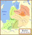
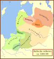
Fitxategi:Baltic Tribes c 1200.svg

Bereizmen handikoa(SVG fitxategia, nominaldi 988 × 1.088 pixel, fitxategiaren tamaina: 789 KB)

Fitxategi hau Wikimedia Commonsekoa da. Hango deskribapen orriko informazioa behean duzu.
Commons gordailu bat da, lizentzia askea duten multimedia fitxategiena. Lagun dezakezu.

Fitxategi hau Wikimedia Commonsekoa da

Laburpena

Deskribapena
Ahal baduzu, lagundu deskribapen hau guztientzako eskuragarri beste hizkuntza batzuetara itzuliz. – Eskerrik asko!

[aldatu]

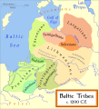
Català: Un mapa de les tribus bàltiques, cap al 1200 d.C. Els bàltics orientals es mostren en tons marrons mentre que els bàltics occidentals es mostren en verd. Els límits són aproximats. Aquest mapa utilitza una projecció de Mercator.
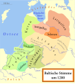
Deutsch: Karte der baltischen Stämme um 1200. Ostbalten in Braun, Westbalten in Grün. Ungefähre Grenzen.
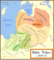
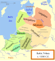
English: A map of the Baltic Tribes, about 1200 AD. The Eastern Balts are shown in brown hues while the Western Balts are shown in green. The boundaries are approximate. This map uses a Mercator projection.
Español: Mapa de las tribus bálticas, alrededor de 1200 d.C. Los bálticos orientales se muestran en tonos marrones, mientras que los bálticos occidentales están mostrados en verde. Las fronteras son aproximadas.
Français : Une carte des peuples baltes vers 1200. Les Baltes orientaux sont représentés en marron, tandis que les Baltes occidentaux sont représentés en vert. Les frontières sont approximatives.
Latviešu: Baltu cilšu apdzīvotās teritorijas aptuveni 12-13 gs. mijā. Robežas ir aptuvenas. Rietumbalti kartē iezīmēt zaļganos toņos, austrumbalti - brūnganos.
Lietuvių: Baltų genčių teritorija apie 1200 metus. Vakarų baltų teritorija yra nuspalvinta žaliomis, rytų - rusvomis spalvomis. Teritorijos yra apytikslės.
Magyar: A balti törzsek területei 1200 körül. A keleti-balt törzseket barnás, a nyugati-baltokat zöldes színek jelölik.
Nederlands: De Baltische volkeren ca. 1200 AD. Oostbalten in bruin, Westbalten in groen. Grenzen zijn bij benadering.
Polski: Mapa ukazuje plemiona Bałtyjskie, około 1200 n.e. Wschodni Bałtowie są w odcieniach brązu, zachodni - zieleni.
Беларуская: Мапа балтыйскіх плямёнаў у канцы 12 — пачату 13 стагодзьдзяў. Тэрыторыі ўсходніх балтаў афарбаваныя ў карычневых адценьнях, у той жа час тэрыторыі заходніх балтаў афарбаваныя ў адценьні зялёнага колеру. Межы ўказаныя прыблізна.
Русский: Карта балтийских племен в конце 12 – начале 13 веков. Территории восточных балтов окрашены в коричневых оттенках, в то время как территории западных балтов окрашены в оттенках зеленого цвета. Границы указаны приблизительно.
Українська: Карта балтійських племен 1200 року. Території східних балтів фарбовані коричневими відтінтакми, а території західних балтів - зеленими. Межі народів вказані умовно.
Data
Jatorria

Norberaren lana, ondorengo hau(ek) oinarri hartuta: a map by Marija Gimbutas, published in The Balts (1963) LCC 63018018. Available at Vaidilute.com (page 23 "Fig. 1. Baltic tribes and provinces c. A.D. 1200" archive). In addition to Gimbutas, other maps were also consulted:

Egilea MapMaster
Beste bertsioak

[aldatu]

SVG genesis
InfoField
 
SVG irudi honen iturburu kodea baliozkoa.
 
Fitxategi hau (bektore-irudia) hau Inkscape-ekin sortu da .

Lizentzia

Nik, lan honen egileak, argitaratzen dut ondorengo lizentzia pean:
GNU head Baimena duzu dokumentu hau kopiatu, banatu edo/eta aldatzeko GNU Free Documentation License baldintzapean, Free Software Foundationek argitaratutako 1.2 edo ondorengo bertsioan; sekzio aldaezinik gabe, azaleko testurik gabe, eta atzeko azaleko testurik gabe. Lizentziaren kopia dago GNU Free Documentation License izenburudun atalean.
w:eu:Creative Commons
eskuduntza berdin partekatu
Fitxategi hau Creative Commons Attribution-Share Alike 3.0 Unported lizentziapean dago.
Askea zara:
  • partekatzeko – lana kopiatzeko, banatzeko eta bidaltzeko
  • birnahasteko – lana moldatzeko
Ondorengo baldintzen pean:
  • eskuduntza – Egiletza behar bezala aitortu behar duzu, lizentzia ikusteko esteka gehitu, eta ea aldaketak egin diren aipatu. Era egokian egin behar duzu hori guztia, baina inola ere ez egileak zure lana edo zure erabilera babesten duela irudikatuz.
  • berdin partekatu – Lan honetan oinarrituta edo aldatuta berria eraikitzen baduzu, emaitza lana hau bezalako lizentzia batekin argitaratu behar duzu.
This licensing tag was added to this file as part of the GFDL licensing update.

Irudi-oineko testuak

Add a one-line explanation of what this file represents

Fitxategi honetan agertzen diren itemak

honako hau irudikatzen du

urtarrila 2007

media type ingelesa

image/svg+xml

checksum ingelesa

beee6d8c2657ebe11214f16c45744947fae12c87

data size ingelesa

808.115 Byte

1.088 pixel

988 pixel

Fitxategiaren historia

Data/orduan klik egin fitxategiak orduan zuen itxura ikusteko.

(Azkenekoak | Lehenbizikoak) Ikusi (berriagoak diren 10) () (10 | 20 | 50 | 100 | 250 | 500).
Data/OrduaIruditxoaNeurriakErabiltzaileaIruzkina
oraingoa06:58, 15 ekaina 202306:58, 15 ekaina 2023 bertsioaren iruditxoa988 × 1.088 (789 KB)Mantulis87Reverted to version as of 23:59, 18 August 2010 (UTC)
06:39, 15 ekaina 202306:39, 15 ekaina 2023 bertsioaren iruditxoa988 × 1.088 (789 KB)Mantulis87Reverted to version as of 21:52, 14 August 2010 (UTC)
01:59, 19 abuztua 201001:59, 19 abuztua 2010 bertsioaren iruditxoa988 × 1.088 (789 KB)Techman224Removed Borders
23:52, 14 abuztua 201023:52, 14 abuztua 2010 bertsioaren iruditxoa988 × 1.088 (789 KB)Vearthy...
23:49, 14 abuztua 201023:49, 14 abuztua 2010 bertsioaren iruditxoa1.003 × 1.096 (790 KB)Vearthysorry, wrong file...
23:47, 14 abuztua 201023:47, 14 abuztua 2010 bertsioaren iruditxoa1.003 × 1.096 (790 KB)Vearthydeleted unneeded contour, done some minor edits (paths)
18:28, 23 otsaila 200818:28, 23 otsaila 2008 bertsioaren iruditxoa1.003 × 1.096 (790 KB)Renata3change green colors as Curonians are west Balts
02:57, 28 urtarrila 200702:57, 28 urtarrila 2007 bertsioaren iruditxoa1.003 × 1.096 (790 KB)MapMasteranother fix
02:50, 28 urtarrila 200702:50, 28 urtarrila 2007 bertsioaren iruditxoa1.003 × 1.096 (786 KB)MapMasterMinor fix
03:38, 17 urtarrila 200703:38, 17 urtarrila 2007 bertsioaren iruditxoa1.003 × 1.096 (788 KB)MapMasterSome adjustments based on Renata3's comments and further research
(Azkenekoak | Lehenbizikoak) Ikusi (berriagoak diren 10) () (10 | 20 | 50 | 100 | 250 | 500).

Hurrengo orrialdeek dute fitxategi honetarako lotura:

Fitxategiaren erabilera orokorra

Hurrengo beste wikiek fitxategi hau darabilte:

Ikus fitxategi honen erabilpen global gehiago.

Metadatuak