Fitxategi:Baikal-S1999276045323.png

Bereizmen handikoa ((1.220 × 858 pixel, fitxategiaren tamaina: 1,9 MB, MIME mota: image/png))
Fitxategi hau Wikimedia Commonsekoa da. Hango deskribapen orriko informazioa behean duzu. |
| Deskribapena |
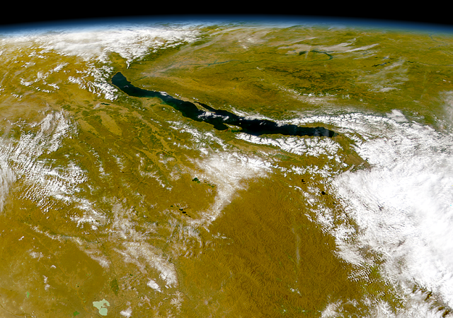
Čeština: Bajkal
|
||||
| Data | |||||
| Jatorria | http://visibleearth.nasa.gov/view_rec.php?id=1002 - http://visibleearth.nasa.gov/images/1002/S1999276045323.png | ||||
| Egilea | Provided by the SeaWiFS Project, NASA/Goddard Space Flight Center, and ORBIMAGE | ||||
| Lizentzia (Fitxategi hau berrerabiltzen) |
|
Fitxategiaren historia
Data/orduan klik egin fitxategiak orduan zuen itxura ikusteko.
| Data/Ordua | Iruditxoa | Neurriak | Erabiltzailea | Iruzkina | |
|---|---|---|---|---|---|
| oraingoa | 05:57, 21 uztaila 2005 | | 1.220 × 858 (1,9 MB) | Bdk | Lake Baikal *Source: http://visibleearth.nasa.gov/view_rec.php?id=1002 - http://visibleearth.nasa.gov/images/1002/S1999276045323.png *Sensor OrbView-2/SeaWiFS *Dates: Datastart 1999-10-03 - Visualization Date 1999-10-03 *Visible Earth v1 ID 3678 *Credit: |
Irudira dakarten loturak
Hurrengo orrialdeek dute fitxategi honetarako lotura:
Fitxategiaren erabilera orokorra
Hurrengo beste wikiek fitxategi hau darabilte:
- ar.wikipedia.org proiektuan duen erabilera
- arz.wikipedia.org proiektuan duen erabilera
- ast.wikipedia.org proiektuan duen erabilera
- as.wikipedia.org proiektuan duen erabilera
- az.wikipedia.org proiektuan duen erabilera
- be.wikipedia.org proiektuan duen erabilera
- ca.wikipedia.org proiektuan duen erabilera
- ce.wikipedia.org proiektuan duen erabilera
- crh.wikipedia.org proiektuan duen erabilera
- cs.wikipedia.org proiektuan duen erabilera
- cy.wikipedia.org proiektuan duen erabilera
- de.wikipedia.org proiektuan duen erabilera
- de.wikivoyage.org proiektuan duen erabilera
- de.wiktionary.org proiektuan duen erabilera
- diq.wikipedia.org proiektuan duen erabilera
- el.wikipedia.org proiektuan duen erabilera
- en.wikipedia.org proiektuan duen erabilera
- eo.wikipedia.org proiektuan duen erabilera
- es.wikipedia.org proiektuan duen erabilera
- fa.wikipedia.org proiektuan duen erabilera
- fr.wikivoyage.org proiektuan duen erabilera
- ga.wikipedia.org proiektuan duen erabilera
- he.wikipedia.org proiektuan duen erabilera
- hr.wikipedia.org proiektuan duen erabilera
- hu.wikipedia.org proiektuan duen erabilera
- hy.wikipedia.org proiektuan duen erabilera
- it.wikipedia.org proiektuan duen erabilera
- ja.wikipedia.org proiektuan duen erabilera
- ka.wikipedia.org proiektuan duen erabilera
- kbp.wikipedia.org proiektuan duen erabilera
- kk.wikipedia.org proiektuan duen erabilera
- lb.wikipedia.org proiektuan duen erabilera
- lmo.wikipedia.org proiektuan duen erabilera
- lv.wikipedia.org proiektuan duen erabilera
- mhr.wikipedia.org proiektuan duen erabilera
- mt.wikipedia.org proiektuan duen erabilera
- myv.wikipedia.org proiektuan duen erabilera
- my.wikipedia.org proiektuan duen erabilera
- mzn.wikipedia.org proiektuan duen erabilera
Ikus fitxategi honen erabilpen global gehiago.