Fitxategi:Antipodes LAEA.png

Aurreikuspen honen neurria: 601 × 600 pixel. Bestelako bereizmenak: 241 × 240 pixel | 481 × 480 pixel | 770 × 768 pixel | 1.026 × 1.024 pixel | 1.829 × 1.825 pixel.
Bereizmen handikoa ((1.829 × 1.825 pixel, fitxategiaren tamaina: 176 KB, MIME mota: image/png))
Fitxategi hau Wikimedia Commonsekoa da. Hango deskribapen orriko informazioa behean duzu. |
Laburpena
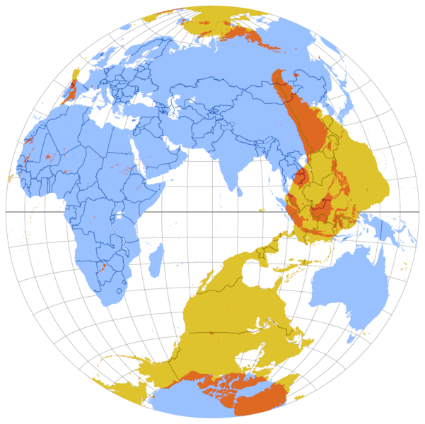
| Deskribapena | Map of antipodes of the Earth, in Lambert Azimuthal Equal-Area projection. |
| Data | Originally uploaded to en.wikipedia on 12:11, 10 August 2007 by en:User:Citynoise |
| Jatorria | Norberak egina |
| Egilea | Originally uploaded to en.wikipedia on 12:11, 10 August 2007 by en:User:Citynoise |
| Beste bertsioak |
See also File:Antipodes LAEA inverted.png,File:WorldMapWithAntipodes.png, File:Antipodes equirectangular.svg |


This image was copied from wikipedia:en:
| date/time | username | resolution | size | edit summary |
|---|---|---|---|---|
| 16:28, 10 August 2007 | ST47 | 1,890×1,890 | 258 KB | |
| 12:11, 10 August 2007 | Citynoise | 1,890×1,890 | 451 KB | Map of antipodes of the Earth, in Lambert Azimuthal Equal-Area projection. |
Lizentzia
This file is licensed under the Creative Commons Attribution-Share Alike 2.5 Generic license.
- Askea zara:
- partekatzeko – lana kopiatzeko, banatzeko eta bidaltzeko
- birnahasteko – lana moldatzeko
- Ondorengo baldintzen pean:
- eskuduntza – Egiletza behar bezala aitortu behar duzu, lizentzia ikusteko esteka gehitu, eta ea aldaketak egin diren aipatu. Era egokian egin behar duzu hori guztia, baina inola ere ez egileak zure lana edo zure erabilera babesten duela irudikatuz.
- berdin partekatu – Lan honetan oinarrituta edo aldatuta berria eraikitzen baduzu, emaitza lana hau bezalako lizentzia batekin argitaratu behar duzu.
Fitxategiaren historia
Data/orduan klik egin fitxategiak orduan zuen itxura ikusteko.
| Data/Ordua | Iruditxoa | Neurriak | Erabiltzailea | Iruzkina | |
|---|---|---|---|---|---|
| oraingoa | 08:08, 23 abendua 2013 | | 1.829 × 1.825 (176 KB) | AnonMoos | cropping, transparency outside map |
| 04:16, 2 uztaila 2011 |  | 1.890 × 1.890 (254 KB) | Jkirkuslamont | Reverted to version as of 02:08, 2 July 2011 | |
| 04:15, 2 uztaila 2011 |  | 1.890 × 1.890 (258 KB) | Jkirkuslamont | Reverted to version as of 12:07, 8 July 2008 - uploaded wrong update file | |
| 04:08, 2 uztaila 2011 |  | 1.890 × 1.890 (254 KB) | Jkirkuslamont | Adjusted hues for colourblindness - shifted pink/magenta to yellow/orange. | |
| 14:07, 8 uztaila 2008 |  | 1.890 × 1.890 (258 KB) | ChongDae | This image was copied from wikipedia:en. The original description was: == Summary == Map of antipodes of the Earth, in Lambert Azimuthal Equal-Area projection. == Licensing == {{cc-by-sa-2.5}} {| border="1" ! date/time || username || resolution || size |
Irudira dakarten loturak
Hurrengo orrialdeek dute fitxategi honetarako lotura:
Fitxategiaren erabilera orokorra
Hurrengo beste wikiek fitxategi hau darabilte:
- ar.wikipedia.org proiektuan duen erabilera
- ast.wikipedia.org proiektuan duen erabilera
- bn.wikipedia.org proiektuan duen erabilera
- de.wikipedia.org proiektuan duen erabilera
- en.wikipedia.org proiektuan duen erabilera
- eo.wikipedia.org proiektuan duen erabilera
- es.wikipedia.org proiektuan duen erabilera
- et.wikipedia.org proiektuan duen erabilera
- fa.wikipedia.org proiektuan duen erabilera
- fi.wiktionary.org proiektuan duen erabilera
- fr.wikipedia.org proiektuan duen erabilera
- ga.wikipedia.org proiektuan duen erabilera
- gl.wikipedia.org proiektuan duen erabilera
- he.wikipedia.org proiektuan duen erabilera
- id.wikipedia.org proiektuan duen erabilera
- ilo.wikipedia.org proiektuan duen erabilera
- ja.wikipedia.org proiektuan duen erabilera
- ko.wikipedia.org proiektuan duen erabilera
- lv.wikipedia.org proiektuan duen erabilera
- ms.wikipedia.org proiektuan duen erabilera
- pl.wikipedia.org proiektuan duen erabilera
- pt.wikipedia.org proiektuan duen erabilera
- th.wikipedia.org proiektuan duen erabilera
- uk.wikipedia.org proiektuan duen erabilera
- vi.wikipedia.org proiektuan duen erabilera
- www.wikidata.org proiektuan duen erabilera
- zh.wikipedia.org proiektuan duen erabilera