Fitxategi:Annobón-es.png

Bereizmen handikoa ((890 × 991 pixel, fitxategiaren tamaina: 166 KB, MIME mota: image/png))
Fitxategi hau Wikimedia Commonsekoa da. Hango deskribapen orriko informazioa behean duzu. |
Laburpena
| Deskribapena |
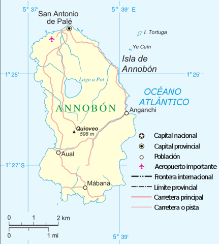
English: Maps of Annobon island, (Equatorial Guinea) in Spanish Español: Mapa de la isla de Annobon, en español |
| Data | |
| Jatorria | Norberak egina |
| Egilea | Basquetteur |
| Beste bertsioak |
Fitxategi hau hemendik eratorria izan da: |
| This image is a map derived from a United Nations map.
Unless stated otherwise, UN maps are to be considered in the public domain. This applies worldwide. UN maps are, in principle, open source material and you can use them in your work or for making your own map. UN requests however that you delete the UN name, logo and reference number upon any modification to the map. Content of your map will be your responsibility. You can state in your publication, if you wish, something like: based on UN map … (map name, map number, revision number and date). See: Geospatial Information Section. And: Geospatial, location data for a better world. |
 |
Lizentzia
- Askea zara:
- partekatzeko – lana kopiatzeko, banatzeko eta bidaltzeko
- birnahasteko – lana moldatzeko
- Ondorengo baldintzen pean:
- eskuduntza – Egiletza behar bezala aitortu behar duzu, lizentzia ikusteko esteka gehitu, eta ea aldaketak egin diren aipatu. Era egokian egin behar duzu hori guztia, baina inola ere ez egileak zure lana edo zure erabilera babesten duela irudikatuz.
- berdin partekatu – Lan honetan oinarrituta edo aldatuta berria eraikitzen baduzu, emaitza lana hau bezalako lizentzia batekin argitaratu behar duzu.
Fitxategiaren historia
Data/orduan klik egin fitxategiak orduan zuen itxura ikusteko.
| Data/Ordua | Iruditxoa | Neurriak | Erabiltzailea | Iruzkina | |
|---|---|---|---|---|---|
| oraingoa | 19:36, 15 ekaina 2016 | | 890 × 991 (166 KB) | W like wiki | Even though the source of this file is the UN, the lower latitude coordinates of Annobón (located on the southern hemisphere!) should be 1°27′S instead of 1°23′ !!!! |
| 22:57, 11 iraila 2014 |  | 890 × 991 (163 KB) | Basquetteur | Océano Atlántico | |
| 15:55, 7 iraila 2014 |  | 890 × 991 (164 KB) | Basquetteur | User created page with UploadWizard |
Irudira dakarten loturak
Hurrengo orrialdeek dute fitxategi honetarako lotura:
Fitxategiaren erabilera orokorra
Hurrengo beste wikiek fitxategi hau darabilte:
- ast.wikipedia.org proiektuan duen erabilera
- en.wikipedia.org proiektuan duen erabilera
- es.wikipedia.org proiektuan duen erabilera
- gl.wikipedia.org proiektuan duen erabilera
- mt.wikipedia.org proiektuan duen erabilera
- pt.wikipedia.org proiektuan duen erabilera
- www.wikidata.org proiektuan duen erabilera