Fitxategi:Adare Peninsula map.jpg
Aurreikuspen honen neurria: 463 × 599 pixel. Bestelako bereizmenak: 185 × 240 pixel | 371 × 480 pixel | 594 × 768 pixel | 792 × 1.024 pixel | 1.475 × 1.908 pixel.
Bereizmen handikoa ((1.475 × 1.908 pixel, fitxategiaren tamaina: 769 KB, MIME mota: image/jpeg))
Fitxategi hau Wikimedia Commonsekoa da. Hango deskribapen orriko informazioa behean duzu. |
Laburpena
| Deskribapena |
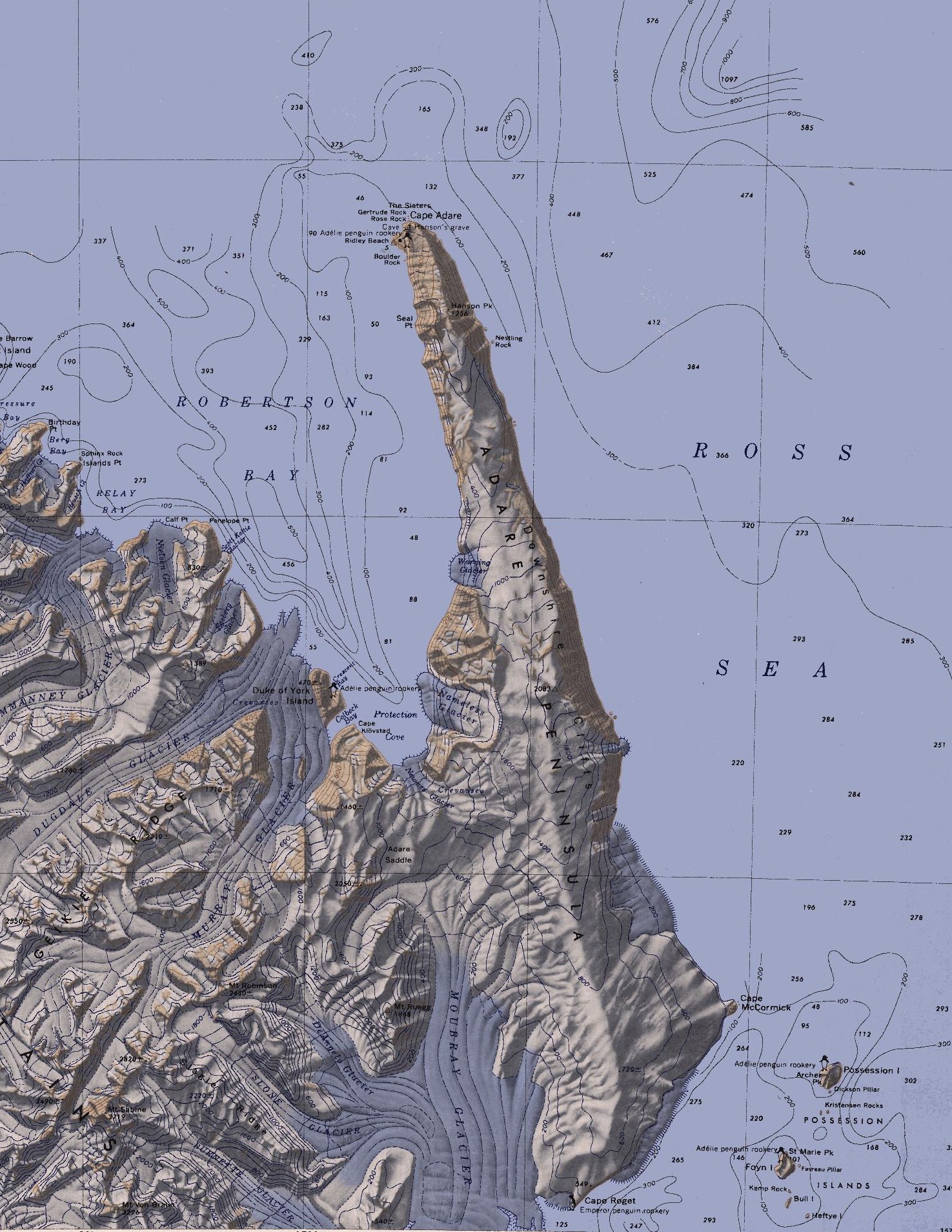
English: Map of the Adare Peninsula west of the Ross Sea. |
| Data | |
| Jatorria | File:C71188s5 Ant.Map Cape Adare.jpg |
| Egilea | U. S. Geological Survey |
Lizentzia
This image is in the public domain in the United States because it only contains materials that originally came from the United States Geological Survey, an agency of the United States Department of the Interior. For more information, see the official USGS copyright policy.
|
Fitxategiaren historia
Data/orduan klik egin fitxategiak orduan zuen itxura ikusteko.
| Data/Ordua | Iruditxoa | Neurriak | Erabiltzailea | Iruzkina | |
|---|---|---|---|---|---|
| oraingoa | 23:51, 11 martxoa 2010 | | 1.475 × 1.908 (769 KB) | 4ing | == {{int:filedesc}} == {{Information |Description={{en|1=Map of Possession Islands in the Ross Sea.}} |Source=File:C71188s5 Ant.Map Cape Adare.jpg |Author=U. S. Geological Survey |Date=1968 |Permission= |other_versions= }} <!--{{ImageUpload|basic}}- |
Irudira dakarten loturak
Hurrengo orrialdeek dute fitxategi honetarako lotura:
Fitxategiaren erabilera orokorra
Hurrengo beste wikiek fitxategi hau darabilte:
- be.wikipedia.org proiektuan duen erabilera
- ceb.wikipedia.org proiektuan duen erabilera
- da.wikipedia.org proiektuan duen erabilera
- de.wikipedia.org proiektuan duen erabilera
- Transantarktisches Gebirge
- Kap Adare
- Adare-Halbinsel
- Kap Roget
- Robertson Bay
- Adare Saddle
- Newnes-Gletscher
- Moubray-Gletscher
- Protection Cove
- Colbeck Bay
- Herzog-von-York-Insel
- Murray-Gletscher
- Dugdale-Gletscher
- Geikie Ridge
- Archer Peak
- Possession Island (Antarktika)
- Possession Islands
- Kap McCormick
- Berg Bay
- Burnette-Gletscher
- Boulder Rock
- Ridley Beach
- Bull Island (Antarktika)
- Kemp Rock
- Heftye Island
- Foyn Island
- Crescent Bay
- DeAngelo-Gletscher
- Mount Robinson (Viktorialand)
- Mount Ruegg
- Dickson Pillar
- Downshire-Kliffs
- Favreau Pillar
- Gertrude Rock
- Rose Rock
- Hanson Peak
- Hargreaves Peak
- Nameless Glacier
- Kristensen Rocks
- Nestling Rock
- Seal Point (Viktorialand)
Ikus fitxategi honen erabilpen global gehiago.