Fitxategi:Acprussiamap2.gif
Ez dago bereizmen handiagorik.
Acprussiamap2.gif ((510 × 357 pixel, fitxategiaren tamaina: 27 KB, MIME mota: image/gif), 0,1s)
Fitxategi hau Wikimedia Commonsekoa da. Hango deskribapen orriko informazioa behean duzu. |

This image was copied from wikipedia:pt. The original description was:
Licença GNU, fonte en:Wikipedia.

|
Baimena duzu dokumentu hau kopiatu, banatu edo/eta aldatzeko GNU Free Documentation License baldintzapean, Free Software Foundationek argitaratutako 1.2 edo ondorengo bertsioan; sekzio aldaezinik gabe, azaleko testurik gabe, eta atzeko azaleko testurik gabe. Lizentziaren kopia dago GNU Free Documentation License izenburudun atalean. |
| Fitxategi hau Creative Commons Attribution-Share Alike 3.0 Unported lizentziapean dago. | ||
| ||
| This licensing tag was added to this file as part of the GFDL licensing update. |

|
This map has been uploaded by Electionworld from en.wikipedia.org to enable the |
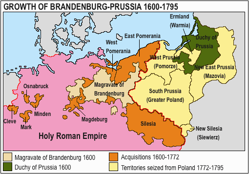
Growth of Prussia en:Image:Ac.prussiamap2.gif

|
Irudi hau birsortu beharko litzateke SVG irudi bektorial moduan. Honek abantaila asko ematen ditu, ikus Commons:Media for cleanup (ingelesez) informazio gehiagorako. Irudi honen SVG bertsioa eskuragarri badago, mesedez Commonsera igo. Igo ostean, ordezkatu txantiloi hau txantiloi honegatik {{vector version available|irudiaren izen berria.svg}} irudi honetan.
|
Fitxategiaren historia
Data/orduan klik egin fitxategiak orduan zuen itxura ikusteko.
| Data/Ordua | Iruditxoa | Neurriak | Erabiltzailea | Iruzkina | |
|---|---|---|---|---|---|
| oraingoa | 15:17, 15 martxoa 2020 | | 510 × 357 (27 KB) | E-960 | Ermland, correction. |
| 14:50, 15 martxoa 2020 |  | 510 × 357 (27 KB) | E-960 | Names of territories and format. | |
| 21:44, 1 ekaina 2009 |  | 510 × 357 (14 KB) | Hohum | Changed colours to more cartographic, less garish. Made sea blue instead of portions of land. | |
| 20:36, 25 abuztua 2006 |  | 510 × 357 (15 KB) | LeonardoG | This image was copied from wikipedia:pt. The original description was: Licença GNU, fonte en:Wikipedia. {{GFDL}} en:Image:Ac.prussiamap2.gif {| border="1" ! date/time || username || resolution || size || edit summary |---- | |} |
Irudira dakarten loturak
Hurrengo orrialdeek dute fitxategi honetarako lotura:
Fitxategiaren erabilera orokorra
Hurrengo beste wikiek fitxategi hau darabilte:
- af.wikipedia.org proiektuan duen erabilera
- ar.wikipedia.org proiektuan duen erabilera
- ast.wikipedia.org proiektuan duen erabilera
- bg.wikipedia.org proiektuan duen erabilera
- ca.wikipedia.org proiektuan duen erabilera
- cs.wikipedia.org proiektuan duen erabilera
- el.wikipedia.org proiektuan duen erabilera
- en.wikipedia.org proiektuan duen erabilera
- History of Germany
- House of Hohenzollern
- Prussia
- Margraviate of Brandenburg
- Prussian Army
- Territorial evolution of Germany
- Subdivisions of the Polish–Lithuanian territories following the partitions
- Prussian Partition
- 18th-century history of Germany
- Brandenburg–Pomeranian conflict
- Treaty of Vossem (1673)
- User:Falcaorib
- User:JMvanDijk/Sandbox 9/Box 15/Box 3
- es.wikipedia.org proiektuan duen erabilera
- et.wikipedia.org proiektuan duen erabilera
- fa.wikipedia.org proiektuan duen erabilera
- fi.wikipedia.org proiektuan duen erabilera
- fr.wikipedia.org proiektuan duen erabilera
- he.wikipedia.org proiektuan duen erabilera
- hy.wikipedia.org proiektuan duen erabilera
- it.wikipedia.org proiektuan duen erabilera
Ikus fitxategi honen erabilpen global gehiago.