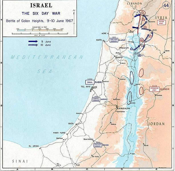
Fitxategi:1967 Six Day War - Battle of Golan Heights.jpg

Bereizmen handikoa ((904 × 884 pixel, fitxategiaren tamaina: 109 KB, MIME mota: image/jpeg))
Fitxategi hau Wikimedia Commonsekoa da. Hango deskribapen orriko informazioa behean duzu. |

|
File:1967 Six Day War - Battle of Golan Heights.svg fitxategi honen bektore bertsioa da. Hau rasterizatutako bertsioaren ordez erabili beharko litzateke hobea izatekotan.
File:1967 Six Day War - Battle of Golan Heights.jpg → File:1967 Six Day War - Battle of Golan Heights.svg
Grafiko bektorialei buruzko informazioa lortzeko, irakurri SVGra trantsizioa Commonsen. MediaWikiko SVG irudien inguruko laguntza teknikoa ere badago. |
 |
- Source: Department of History, U.S. Military Academy
- URL: [1] archive copy at the Wayback Machine
- Background information:
In 1938 the predecessors of what is today The Department of History at the United States Military Academy began developing a series of campaign atlases to aid in teaching cadets a course entitled, "History of the Military Art." Since then, the Department has produced over six atlases and more than one thousand maps, encompassing not only America’s wars but global conflicts as well.
In keeping abreast with today's technology, the Department of History is providing these maps on the internet as part of the department's outreach program. The maps were created by the United States Military Academy’s Department of History and are the digital versions from the atlases printed by the United States Defense Printing Agency. We gratefully acknowledge the accomplishments of the department's former cartographer, Mr. Edward J. Krasnoborski, along with the works of our present cartographer, Mr. Frank Martini.
Please be aware that these maps are large in file size and may require substantial download times.
This file is a work of a U.S. Army soldier or employee, taken or made as part of that person's official duties. As a work of the U.S. federal government, it is in the public domain in the United States.
|
 |
derivative works
Derivative works of this file: Israel 1949-1967.svg
Fitxategiaren historia
Data/orduan klik egin fitxategiak orduan zuen itxura ikusteko.
| Data/Ordua | Iruditxoa | Neurriak | Erabiltzailea | Iruzkina | |
|---|---|---|---|---|---|
| oraingoa | 12:29, 24 uztaila 2005 | | 904 × 884 (109 KB) | Humus sapiens~commonswiki | *Source: Department of History, U.S. Military Academy *URL: [http://www.dean.usma.edu/history/web03/atlases/map%20home.htm] *Background information: ''In 1938 the predecessors of what is today The Department of History at the United States Military Acade |
Irudira dakarten loturak
Ez dago fitxategi hau darabilen orririk.
Fitxategiaren erabilera orokorra
Hurrengo beste wikiek fitxategi hau darabilte:
- en.wikipedia.org proiektuan duen erabilera
- nl.wikipedia.org proiektuan duen erabilera