Fitxategi:17th century Spanish routes to Petén flat.gif

Aurreikuspen honen neurria: 492 × 600 pixel. Bestelako bereizmenak: 197 × 240 pixel | 394 × 480 pixel | 630 × 768 pixel | 1.152 × 1.404 pixel.
Bereizmen handikoa ((1.152 × 1.404 pixel, fitxategiaren tamaina: 516 KB, MIME mota: image/gif))
Fitxategi hau Wikimedia Commonsekoa da. Hango deskribapen orriko informazioa behean duzu. |
Laburpena
| Deskribapena |
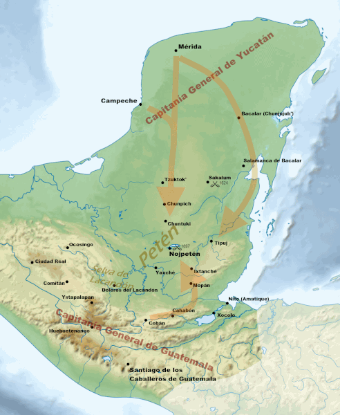
English: Routes of approach by the Spanish against the fiercely independent Itza and their neighbours during the 17th century. For layer data see File:17th century Spanish routes to Petén.xcf
Sources:
Español: Rutas de entrada de los españoles contra los itzaes y sus vecinos en el siglo XVII. Para ver datos de capas, véase File:17th century Spanish routes to Petén.xcf
Fuentes:
|
| Data | |
| Jatorria | |
| Egilea |
|
| Beste bertsioak | العربيَّة |
| This is a retouched picture, which means that it has been digitally altered from its original version. Modifications: Cropped and added 17th century locations and battles, geographical regions etc. The original can be viewed here: Maya civilization location map-blank.svg:
|
Lizentzia
Nik, lan honen egileak, argitaratzen dut ondorengo lizentzia pean:
Fitxategi hau Creative Commons Attribution-Share Alike 3.0 Unported lizentziapean dago.
- Askea zara:
- partekatzeko – lana kopiatzeko, banatzeko eta bidaltzeko
- birnahasteko – lana moldatzeko
- Ondorengo baldintzen pean:
- eskuduntza – Egiletza behar bezala aitortu behar duzu, lizentzia ikusteko esteka gehitu, eta ea aldaketak egin diren aipatu. Era egokian egin behar duzu hori guztia, baina inola ere ez egileak zure lana edo zure erabilera babesten duela irudikatuz.
- berdin partekatu – Lan honetan oinarrituta edo aldatuta berria eraikitzen baduzu, emaitza lana hau bezalako lizentzia batekin argitaratu behar duzu.
Fitxategiaren historia
Data/orduan klik egin fitxategiak orduan zuen itxura ikusteko.
| Data/Ordua | Iruditxoa | Neurriak | Erabiltzailea | Iruzkina | |
|---|---|---|---|---|---|
| oraingoa | 21:29, 29 apirila 2013 | | 1.152 × 1.404 (516 KB) | Simon Burchell | +location of Dolores del Lacandón, move Ystapalapán |
| 11:35, 28 apirila 2013 |  | 1.152 × 1.404 (515 KB) | Simon Burchell | +3 colonial towns in Chiapas | |
| 10:18, 27 apirila 2013 |  | 1.152 × 1.404 (514 KB) | Simon Burchell | Clarify the Bacalars | |
| 22:22, 26 apirila 2013 |  | 1.152 × 1.404 (513 KB) | Simon Burchell | Extend arrow towards Mérida | |
| 20:36, 26 apirila 2013 |  | 1.152 × 1.404 (513 KB) | Simon Burchell | User created page with UploadWizard |
Irudira dakarten loturak
Hurrengo orrialdeek dute fitxategi honetarako lotura:
Fitxategiaren erabilera orokorra
Hurrengo beste wikiek fitxategi hau darabilte:
- ar.wikipedia.org proiektuan duen erabilera
- ast.wikipedia.org proiektuan duen erabilera
- en.wikipedia.org proiektuan duen erabilera
- es.wikipedia.org proiektuan duen erabilera
- ja.wikipedia.org proiektuan duen erabilera
- pnb.wikipedia.org proiektuan duen erabilera
- ur.wikipedia.org proiektuan duen erabilera