Fitxategi:Shelby County Illinois Incorporated and Unincorporated areas Windsor Highlighted.svg

SVG fitxategi honen PNG aurreikuspenaren tamaina: 502 × 292 pixel. Bestelako bereizmenak: 320 × 186 pixel | 640 × 372 pixel | 1.024 × 596 pixel | 1.280 × 745 pixel | 2.560 × 1.489 pixel.
Bereizmen handikoa (SVG fitxategia, nominaldi 502 × 292 pixel, fitxategiaren tamaina: 401 KB)
Fitxategi hau Wikimedia Commonsekoa da. Hango deskribapen orriko informazioa behean duzu. |
Laburpena
| Deskribapena |
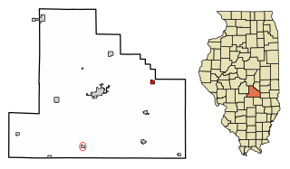
My own work, based on public domain information. Based on similar map concepts by w:User:Arkyan This map shows the incorporated and unincorporated areas in Mercer County, Illinois, highlighting Windsor in red. It was created from US Census Bureau data with the help of a custom fork of the kartography project, available on Github at |
| Jatorria | Own work by the original uploader |
| Egilea | DemocraticLuntz |
Lizentzia
github.com/jacobmas/kartograph.py
DemocraticLuntz at ingelesa Wikipedia, lan honen egileak, argitaratu du edo argitaratzen du ondorengo lizentzia pean:
If this file is eligible for relicensing, it may also be used under the Creative Commons Attribution-ShareAlike 3.0 license. The relicensing status of this image has not yet been reviewed. You can help.
|

|
Baimena duzu dokumentu hau kopiatu, banatu edo/eta aldatzeko GNU Free Documentation License baldintzapean, Free Software Foundationek argitaratutako 1.2 edo ondorengo bertsioan; sekzio aldaezinik gabe, azaleko testurik gabe, eta atzeko azaleko testurik gabe. Lizentziaren kopia dago GNU Free Documentation License izenburudun atalean. Subject to disclaimers. |
Jatorrizko igoera erregistroa
The original description page was here. All following user names refer to en.wikipedia.
| Data/Ordua | Neurriak | Erabiltzailea | Iruzkina |
|---|---|---|---|
| 2017-07-12 16:54:02 | 502 × 292 | DemocraticLuntz | |
| 2017-07-11 19:18:00 | 502 × 292 | DemocraticLuntz | |
| 2017-07-10 20:36:34 | 502 × 292 | DemocraticLuntz | |
| 2017-07-07 20:17:30 | 502 × 323 | DemocraticLuntz | |
| 2017-06-28 20:08:38 | 502 × 325 | DemocraticLuntz | Fixed software creating these |
| 2017-06-23 20:40:00 | 502 × 501 | DemocraticLuntz | My own work, based on public domain information. Based on similar map concepts by [[User:Arkyan]] This map shows the incorporated and unincorporated areas in Mercer County, Illinois, highlighting Windsor in red. It was created from US Census Bureau da... |
Fitxategiaren historia
Data/orduan klik egin fitxategiak orduan zuen itxura ikusteko.
| Data/Ordua | Iruditxoa | Neurriak | Erabiltzailea | Iruzkina | |
|---|---|---|---|---|---|
| oraingoa | 04:15, 26 urria 2017 | | 502 × 292 (401 KB) | OgreBot | (BOT): Reverting to most recent version before archival |
| 04:15, 26 urria 2017 |  | 502 × 292 (401 KB) | OgreBot | (BOT): Uploading old version of file from en.wikipedia; originally uploaded on 2017-07-11 19:18:00 by DemocraticLuntz | |
| 04:15, 26 urria 2017 |  | 502 × 292 (400 KB) | OgreBot | (BOT): Uploading old version of file from en.wikipedia; originally uploaded on 2017-07-10 20:36:34 by DemocraticLuntz | |
| 04:15, 26 urria 2017 |  | 502 × 323 (401 KB) | OgreBot | (BOT): Uploading old version of file from en.wikipedia; originally uploaded on 2017-07-07 20:17:30 by DemocraticLuntz | |
| 04:15, 26 urria 2017 |  | 502 × 325 (403 KB) | OgreBot | (BOT): Uploading old version of file from en.wikipedia; originally uploaded on 2017-06-28 20:08:38 by DemocraticLuntz | |
| 04:15, 26 urria 2017 |  | 502 × 501 (408 KB) | OgreBot | (BOT): Uploading old version of file from en.wikipedia; originally uploaded on 2017-06-23 20:40:00 by DemocraticLuntz | |
| 00:00, 25 urria 2017 |  | 502 × 292 (401 KB) | FSock | Transferred from en.wikipedia (MTC!) (1.1.1) |
Irudira dakarten loturak
Hurrengo orrialdeek dute fitxategi honetarako lotura:
Fitxategiaren erabilera orokorra
Hurrengo beste wikiek fitxategi hau darabilte:
- ar.wikipedia.org proiektuan duen erabilera
- arz.wikipedia.org proiektuan duen erabilera
- azb.wikipedia.org proiektuan duen erabilera
- ca.wikipedia.org proiektuan duen erabilera
- en.wikipedia.org proiektuan duen erabilera
- fr.wikipedia.org proiektuan duen erabilera
- ht.wikipedia.org proiektuan duen erabilera
- sv.wikipedia.org proiektuan duen erabilera
- tt.wikipedia.org proiektuan duen erabilera
- ur.wikipedia.org proiektuan duen erabilera
- vi.wikipedia.org proiektuan duen erabilera
- www.wikidata.org proiektuan duen erabilera
- zh.wikipedia.org proiektuan duen erabilera