Fitxategi:Satellite image of Spain in January 2003.jpg

Aurreikuspen honen neurria: 714 × 600 pixel. Bestelako bereizmenak: 286 × 240 pixel | 571 × 480 pixel | 914 × 768 pixel | 1.219 × 1.024 pixel | 2.437 × 2.048 pixel | 4.175 × 3.508 pixel.
Bereizmen handikoa ((4.175 × 3.508 pixel, fitxategiaren tamaina: 2,42 MB, MIME mota: image/jpeg))
Fitxategi hau Wikimedia Commonsekoa da. Hango deskribapen orriko informazioa behean duzu. |
| Deskribapena |
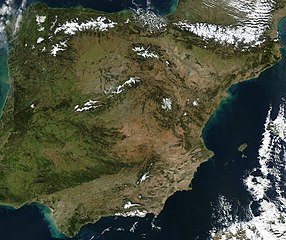
Satellite image of Spain in January 2003. Slightly cropped image, original taken from NASA's Visible Earth http://visibleearth.nasa.gov/view_rec.php?id=4989. NASA's description: The Iberian Peninsula, home to the countries of Spain and Portugal, stretches toward North Africa in this true-color Aqua MODIS image from January 24, 2003. Portugal sits on the Atlantic side of the peninsula, while Spain takes up the rest and shares a border with France to the northeast. At the bottom of the peninsula is a narrow gap between Europe and North Africa. This gap is the Strait of Gibraltar, which also serves as the buffer between the Atlantic Ocean and the Mediterranean Sea. The northern point of Morocco occupies the other side of the Strait, and farther to the east is northern Algeria. |
| Data | |
| Jatorria | http://visibleearth.nasa.gov/view_rec.php?id=4989 |
| Egilea | Jacques Descloitres, MODIS Rapid Response Team, NASA/GSFC |
| This file is in the public domain in the United States because it was solely created by NASA. NASA copyright policy states that "NASA material is not protected by copyright unless noted". (See Template:PD-USGov, NASA copyright policy page or JPL Image Use Policy.) | ||
 |
Warnings:
|
Fitxategiaren historia
Data/orduan klik egin fitxategiak orduan zuen itxura ikusteko.
| Data/Ordua | Iruditxoa | Neurriak | Erabiltzailea | Iruzkina | |
|---|---|---|---|---|---|
| oraingoa | 14:54, 20 abendua 2004 | | 4.175 × 3.508 (2,42 MB) | Hautala | {{PD-USGov-NASA}} Satellite image of Spain in January 2003. Slightly cropped image, original taken from NASA's Visible Earth http://visibleearth.nasa.gov/cgi-bin/viewrecord?24848 . Description: The Iberian Peninsula, home to the countries of Spain and Por |
Irudira dakarten loturak
Hurrengo orrialdeek dute fitxategi honetarako lotura:
Fitxategiaren erabilera orokorra
Hurrengo beste wikiek fitxategi hau darabilte:
- af.wikipedia.org proiektuan duen erabilera
- en.wikipedia.org proiektuan duen erabilera
- es.wikipedia.org proiektuan duen erabilera
- he.wikipedia.org proiektuan duen erabilera
- ht.wikipedia.org proiektuan duen erabilera
- hu.wikipedia.org proiektuan duen erabilera
- incubator.wikimedia.org proiektuan duen erabilera
- it.wikibooks.org proiektuan duen erabilera
- it.wiktionary.org proiektuan duen erabilera
- nl.wikipedia.org proiektuan duen erabilera
- pt.wikipedia.org proiektuan duen erabilera
- uk.wikipedia.org proiektuan duen erabilera