Fitxategi:Round Tower - Clondalkin - geograph.org.uk - 108911.jpg
Aurreikuspen honen neurria: 449 × 600 pixel. Bestelako bereizmenak: 179 × 240 pixel | 479 × 640 pixel.
Bereizmen handikoa ((479 × 640 pixel, fitxategiaren tamaina: 66 KB, MIME mota: image/jpeg))
Fitxategi hau Wikimedia Commonsekoa da. Hango deskribapen orriko informazioa behean duzu. |
Laburpena
| Deskribapena |
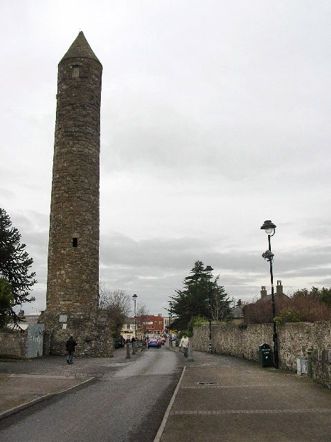
English: Round Tower - Clondalkin. Well preserved 8th century round tower that acts as a focal point for the area. Acknowledged as one of the oldest and best preserved in the country, it is 84 feet high and has its original conical cap. The foundation of the first monastery is attributed to St. Cronan, otherwise called Mo-Chua, who lived possibly in the 6th century. The monastery is first mentioned in 776. It was plundered by the Vikings in 832. [info from http://www.irish-architecture.com] |
| Data | |
| Jatorria | From geograph.org.uk |
| Egilea | Paul Johnston-Knight |
| Aitortu (required by the license) | Paul Johnston-Knight / Round Tower - Clondalkin / |
| Objektuaren kokapena | | Irudi hau eta gehiago beraien kokapenekin hurrengo lekuetan: OpenStreetMap |
|---|
_heading:0.00&language=eu)
Lizentzia

|
This image was taken from the Geograph project collection. See this photograph's page on the Geograph website for the photographer's contact details. The copyright on this image is owned by Paul Johnston-Knight and is licensed for reuse under the Creative Commons Attribution-ShareAlike 2.0 license.
|
This file is licensed under the Creative Commons Attribution-Share Alike 2.0 Generic license.
Aitortu: Paul Johnston-Knight
- Askea zara:
- partekatzeko – lana kopiatzeko, banatzeko eta bidaltzeko
- birnahasteko – lana moldatzeko
- Ondorengo baldintzen pean:
- eskuduntza – Egiletza behar bezala aitortu behar duzu, lizentzia ikusteko esteka gehitu, eta ea aldaketak egin diren aipatu. Era egokian egin behar duzu hori guztia, baina inola ere ez egileak zure lana edo zure erabilera babesten duela irudikatuz.
- berdin partekatu – Lan honetan oinarrituta edo aldatuta berria eraikitzen baduzu, emaitza lana hau bezalako lizentzia batekin argitaratu behar duzu.
Fitxategiaren historia
Data/orduan klik egin fitxategiak orduan zuen itxura ikusteko.
| Data/Ordua | Iruditxoa | Neurriak | Erabiltzailea | Iruzkina | |
|---|---|---|---|---|---|
| oraingoa | 11:31, 8 apirila 2011 | | 479 × 640 (66 KB) | Hydro | Tonwertkorrektur |
| 03:33, 31 urtarrila 2010 |  | 479 × 640 (60 KB) | GeographBot | == {{int:filedesc}} == {{Information |description={{en|1=Round Tower - Clondalkin. Well preserved 8th century round tower that acts as a focal point for the area. Acknowledged as one of the oldest and best preserved in the country, it is 84 feet high and |
Irudira dakarten loturak
Hurrengo orrialdeek dute fitxategi honetarako lotura:
Fitxategiaren erabilera orokorra
Hurrengo beste wikiek fitxategi hau darabilte:
- be-tarask.wikipedia.org proiektuan duen erabilera
- bg.wikipedia.org proiektuan duen erabilera
- ca.wikipedia.org proiektuan duen erabilera
- ceb.wikipedia.org proiektuan duen erabilera
- de.wikipedia.org proiektuan duen erabilera
- en.wikipedia.org proiektuan duen erabilera
- es.wikipedia.org proiektuan duen erabilera
- fa.wikipedia.org proiektuan duen erabilera
- fr.wikipedia.org proiektuan duen erabilera
- ga.wikipedia.org proiektuan duen erabilera
- gd.wikipedia.org proiektuan duen erabilera
- he.wikipedia.org proiektuan duen erabilera
- it.wikipedia.org proiektuan duen erabilera
- ka.wikipedia.org proiektuan duen erabilera
- nl.wikipedia.org proiektuan duen erabilera
- pl.wikipedia.org proiektuan duen erabilera
- ru.wikipedia.org proiektuan duen erabilera
- sl.wikipedia.org proiektuan duen erabilera
- sv.wikipedia.org proiektuan duen erabilera
- ur.wikipedia.org proiektuan duen erabilera
- www.wikidata.org proiektuan duen erabilera