Fitxategi:Laghetto Moesola und Hospiz am San Bernardino Pass.jpg

Aurreikuspen honen neurria: 800 × 254 pixel. Bestelako bereizmenak: 320 × 102 pixel | 640 × 203 pixel | 1.024 × 325 pixel | 1.280 × 406 pixel | 2.560 × 813 pixel | 7.319 × 2.324 pixel.
Bereizmen handikoa ((7.319 × 2.324 pixel, fitxategiaren tamaina: 12,68 MB, MIME mota: image/jpeg))
Fitxategi hau Wikimedia Commonsekoa da. Hango deskribapen orriko informazioa behean duzu. |
| Deskribapena |
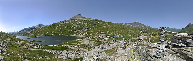
Deutsch: Der San-Bernardino-Pass ist ein Alpenpass im schweizerischen Kanton Graubünden mit einer Scheitelhöhe von 2'065 m. Er verbindet die Täler Rheinwald auf der nördlichen und Misox auf der südlichen Seite an der Hauptstrasse 13. Auf der Passhöhe verlaufen die Europäische Wasserscheide und die Sprachgrenze zwischen Deutsch und Italienisch. Am Östlichen Ufer des Laghetto Moesola verläuft die Pass Straße.
English: The San Bernardino Pass is a mountain pass in the Swiss canton of Graubünden with a summit altitude of 2,065 m. It connects the valleys of the Rhine forest on the northern and Misox on the southern side of the main road 13 At the summit, the European watershed and extend the language border between German and Italian. On the eastern shore of Laghetto Moesola the pass road runs.
|
||
| Data | |||
| Jatorria | Norberak egina | ||
| Egilea |
|
||
| Lizentzia (Fitxategi hau berrerabiltzen) |
Nik, lan honen egileak, argitaratzen dut ondorengo lizentzia pean: This file is licensed under the Creative Commons Attribution-Share Alike 3.0 Austria license.
 |

| Kameraren kokapena | | Irudi hau eta gehiago beraien kokapenekin hurrengo lekuetan: OpenStreetMap |
|---|
|
Fitxategiaren historia
Data/orduan klik egin fitxategiak orduan zuen itxura ikusteko.
| Data/Ordua | Iruditxoa | Neurriak | Erabiltzailea | Iruzkina | |
|---|---|---|---|---|---|
| oraingoa | 22:20, 18 iraila 2013 | 7.319 × 2.324 (12,68 MB) | Böhringer | {{Information |Description= {{de|Der San-Bernardino-Pass ist ein Alpenpass im schweizerischen Kanton Graubünden mit einer Scheitelhöhe von 2'065 m. Er verbindet die Täler Rheinwald auf der nörd... |
Irudira dakarten loturak
Hurrengo orrialdeek dute fitxategi honetarako lotura:
Fitxategiaren erabilera orokorra
Hurrengo beste wikiek fitxategi hau darabilte:
- ca.wikipedia.org proiektuan duen erabilera
- de.wikipedia.org proiektuan duen erabilera
- en.wikipedia.org proiektuan duen erabilera
- mg.wikipedia.org proiektuan duen erabilera
- vi.wikipedia.org proiektuan duen erabilera