Fitxategi:High Asia Mountain Ranges.jpg

Aurreikuspen honen neurria: 763 × 600 pixel. Bestelako bereizmenak: 306 × 240 pixel | 611 × 480 pixel | 978 × 768 pixel | 1.280 × 1.006 pixel | 2.560 × 2.011 pixel | 5.600 × 4.400 pixel.
Bereizmen handikoa ((5.600 × 4.400 pixel, fitxategiaren tamaina: 10,79 MB, MIME mota: image/jpeg))
Fitxategi hau Wikimedia Commonsekoa da. Hango deskribapen orriko informazioa behean duzu. |
Laburpena
| Deskribapena |
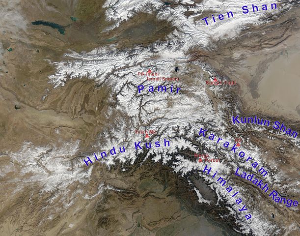
English: high Asian mountain ranges and their highest mountains:
Deutsch: Die innerasiatischen Hochgebirge:
|
| Data | (UTC) |
| Jatorria |
Fitxategi hau hemendik eratorria izan da: Hindu Kush satellite image.jpg: |
| Egilea |
|
| This is a retouched picture, which means that it has been digitally altered from its original version. Modifications: mountain ranges (and highest mountains) labelled. The original can be viewed here: Hindu Kush satellite image.jpg:
|
Lizentzia
| This file is in the public domain in the United States because it was solely created by NASA. NASA copyright policy states that "NASA material is not protected by copyright unless noted". (See Template:PD-USGov, NASA copyright policy page or JPL Image Use Policy.) | ||
 |
Warnings:
|
Jatorrizko igoera erregistroa
This image is a derivative work of the following images:
- File:Hindu_Kush_satellite_image.jpg licensed with PD-USGov-NASA
- 2006-06-06T04:39:19Z Avenue 5600x4400 (5255682 Bytes) {{Information |Description=The Hindu Kush occupies the lower-left-center of this true-color MODIS satellite image, acquired 28 November 2003. |Source=[NASA's Earth Observatory http://earthobservatory.nasa.gov/Newsroom/NewImag
Uploaded with derivativeFX
Fitxategiaren historia
Data/orduan klik egin fitxategiak orduan zuen itxura ikusteko.
| Data/Ordua | Iruditxoa | Neurriak | Erabiltzailea | Iruzkina | |
|---|---|---|---|---|---|
| oraingoa | 15:05, 27 azaroa 2012 | | 5.600 × 4.400 (10,79 MB) | Rupert Pupkin | ladakh range added |
| 13:15, 27 azaroa 2012 |  | 5.600 × 4.400 (10,71 MB) | Rupert Pupkin | == {{int:filedesc}} == {{Information |Description=The Hindu Kush occupies the lower-left-center of this true-color MODIS satellite image, acquired 28 November 2003. |Source={{Derived from|Hindu_Kush_satellite_image.jpg|display=50}} |Date=2012-11-27 11:... |
Irudira dakarten loturak
Hurrengo orrialdeek dute fitxategi honetarako lotura:
Fitxategiaren erabilera orokorra
Hurrengo beste wikiek fitxategi hau darabilte:
- af.wikipedia.org proiektuan duen erabilera
- ba.wikipedia.org proiektuan duen erabilera
- bcl.wikipedia.org proiektuan duen erabilera
- bn.wikipedia.org proiektuan duen erabilera
- ceb.wikipedia.org proiektuan duen erabilera
- de.wikipedia.org proiektuan duen erabilera
- en.wikipedia.org proiektuan duen erabilera
- en.wikivoyage.org proiektuan duen erabilera
- es.wikipedia.org proiektuan duen erabilera
- fa.wikipedia.org proiektuan duen erabilera
- fa.wikivoyage.org proiektuan duen erabilera
- fr.wikipedia.org proiektuan duen erabilera
- hy.wikipedia.org proiektuan duen erabilera
- id.wikipedia.org proiektuan duen erabilera
- it.wikipedia.org proiektuan duen erabilera
- lt.wikipedia.org proiektuan duen erabilera
- ms.wikipedia.org proiektuan duen erabilera
- nl.wikipedia.org proiektuan duen erabilera
- pl.wikipedia.org proiektuan duen erabilera
- pnb.wikipedia.org proiektuan duen erabilera
- ps.wikipedia.org proiektuan duen erabilera
- pt.wikipedia.org proiektuan duen erabilera
- ru.wikipedia.org proiektuan duen erabilera
- sco.wikipedia.org proiektuan duen erabilera
- sd.wikipedia.org proiektuan duen erabilera
- simple.wikipedia.org proiektuan duen erabilera
- sl.wikipedia.org proiektuan duen erabilera
- sv.wikipedia.org proiektuan duen erabilera
- ta.wikipedia.org proiektuan duen erabilera
Ikus fitxategi honen erabilpen global gehiago.