Fitxategi:Geofeatures map of Kanto Japan ja.svg

SVG fitxategi honen PNG aurreikuspenaren tamaina: 600 × 600 pixel. Bestelako bereizmenak: 240 × 240 pixel | 480 × 480 pixel | 768 × 768 pixel | 1.024 × 1.024 pixel | 2.048 × 2.048 pixel | 700 × 700 pixel.
Bereizmen handikoa (SVG fitxategia, nominaldi 700 × 700 pixel, fitxategiaren tamaina: 1,94 MB)
Fitxategi hau Wikimedia Commonsekoa da. Hango deskribapen orriko informazioa behean duzu. |
Laburpena
| Deskribapena |
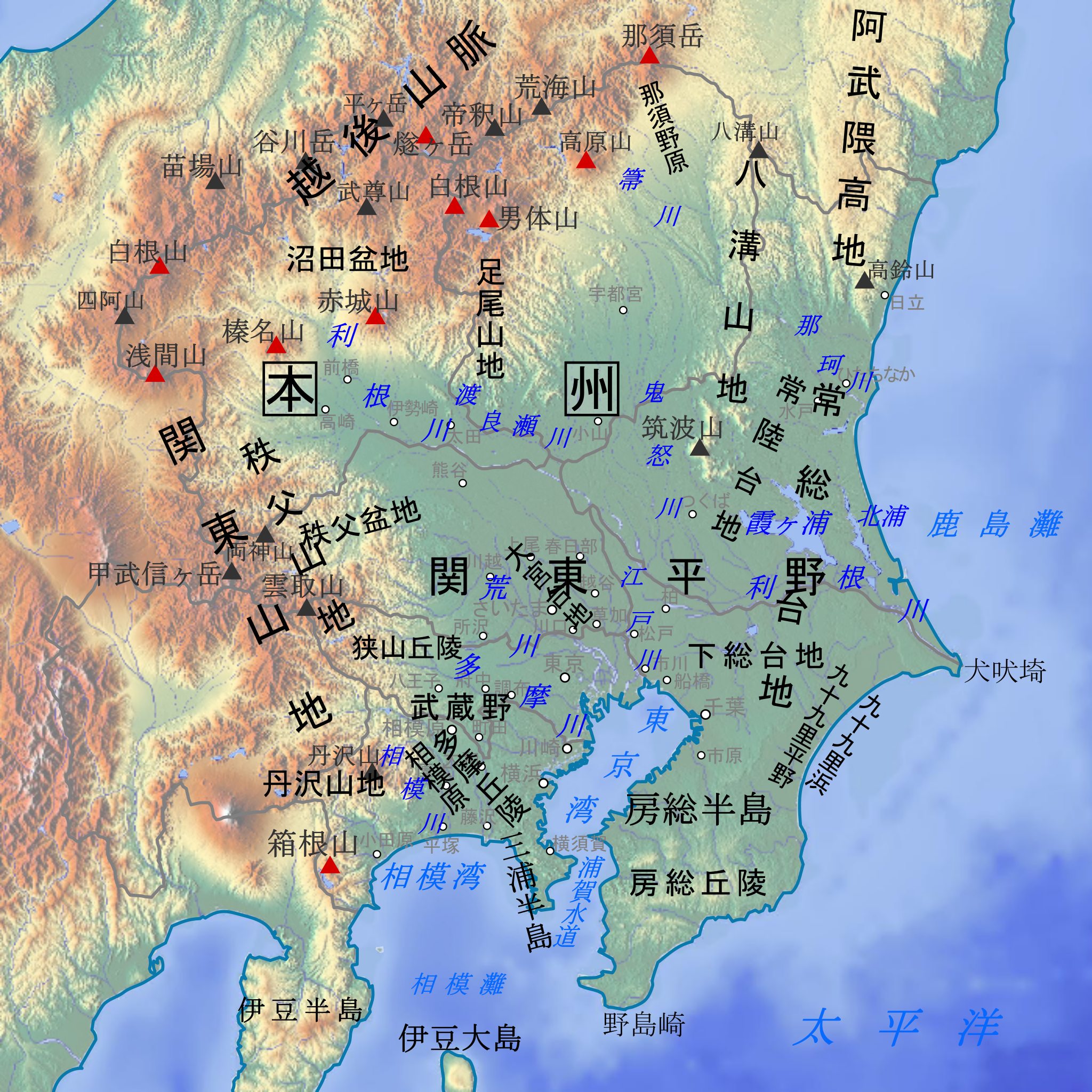
日本語: 関東地方の主要地形名(山地、平野、海域など)を示した地形図。説明:日本語。
各地形の名称と位置は原則として『新版日本国勢地図』(1990年, 国土地理院HP公開版)に準拠。山岳名や河川名、都市名など一部は電子国土基本図(地理院地図)を参照した。
English: Geographical features map of Kanto Region in Japan with Japanese language description. |
| Data | |
| Jatorria | Original map:maps-for-free.com |
| Egilea |
Original map:maps-for-free.com(Hans Braxmeier) |
Fitxategi hau (bektore-irudia) hau Inkscape-ekin sortu da .
.
Lizentzia
| This file is made available under the Creative Commons CC0 1.0 Universal Public Domain Dedication. | |
| The person who associated a work with this deed has dedicated the work to the public domain by waiving all of their rights to the work worldwide under copyright law, including all related and neighboring rights, to the extent allowed by law. You can copy, modify, distribute and perform the work, even for commercial purposes, all without asking permission.
|
Fitxategiaren historia
Data/orduan klik egin fitxategiak orduan zuen itxura ikusteko.
| Data/Ordua | Iruditxoa | Neurriak | Erabiltzailea | Iruzkina | |
|---|---|---|---|---|---|
| oraingoa | 07:51, 28 abendua 2017 | | 700 × 700 (1,94 MB) | Peka | User created page with UploadWizard |
Irudira dakarten loturak
Hurrengo orrialdeek dute fitxategi honetarako lotura:
Fitxategiaren erabilera orokorra
Hurrengo beste wikiek fitxategi hau darabilte:
- af.wikipedia.org proiektuan duen erabilera
- ca.wikipedia.org proiektuan duen erabilera
- en.wikipedia.org proiektuan duen erabilera
- ga.wikipedia.org proiektuan duen erabilera
- gl.wikipedia.org proiektuan duen erabilera
- hy.wikipedia.org proiektuan duen erabilera
- incubator.wikimedia.org proiektuan duen erabilera
- ja.wikipedia.org proiektuan duen erabilera
- ja.wikibooks.org proiektuan duen erabilera
- ja.wikivoyage.org proiektuan duen erabilera
- ko.wikipedia.org proiektuan duen erabilera
- ru.wikipedia.org proiektuan duen erabilera
- sl.wikipedia.org proiektuan duen erabilera
- uk.wikipedia.org proiektuan duen erabilera
- uz.wikipedia.org proiektuan duen erabilera
- www.wikidata.org proiektuan duen erabilera
- zh.wikipedia.org proiektuan duen erabilera