Fitxategi:Dolina-Pano-3.jpg
Bereizmen handikoa ((1.500 × 2.607 pixel, fitxategiaren tamaina: 6,83 MB, MIME mota: image/jpeg))
Fitxategi hau Wikimedia Commonsekoa da. Hango deskribapen orriko informazioa behean duzu. |
Laburpena
| Deskribapena |
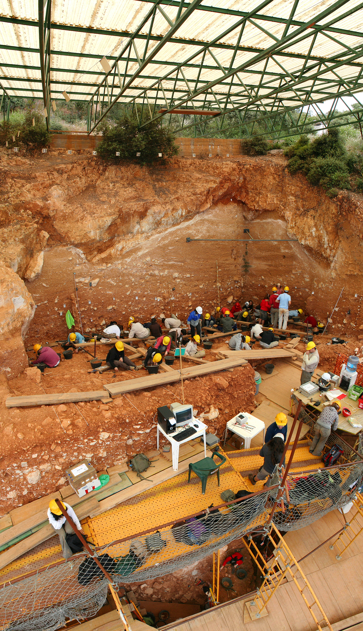
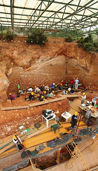
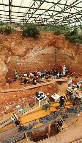
English: Excavations at the site of Gran Dolina, in Atapuerca (Spain), during 2008. Panoramic photography formed using 3 individual photographies with Hugin software. TD-10 archaeological level is being excavated where the most of the people are. It is a Homo heidelbergensis camp. Under the plank, we can observe a woman with red sweatshirt excavating TD-6 archaeological level, where were found the first remains of Homo antecessor.
Español: Excavaciones en el yacimiento de Gran Dolina, en Atapuerca (España), durante el año 2008. Fotografía panorámica formada a partir de 3 fotografías individuales usando Hugin. La excavación en la parte superior se corresponde con el nivel arqueológico TD-10, el cuál es un campamento de Homo heidelbergensis. La parte inferior, debajo de los tablones, se observa a una excavadora con sudadera roja que excava el nivel TD-6, donde aparecieron los restos del Homo antecessor.
Français : Fouilles menées en 2008 sur le site de Gran Dolina dans la Sierra d'Atapuerca, située dans la commune d'Atapuerca dans la province de Burgos en Castille-et-León (Espagne). Image panoramique obtenue en assemblant trois clichés avec le logiciel Hugin. Le niveau archéologique TD10, où se trouvent la plupart des personnes, est un camp d'Homo heidelbergensis. Sous les planches, on distingue une personne travaillant sur le niveau TD6, où ont été trouvés les premiers restes d'Homo antecessor.
Русский: Археологические раскопки в Атапуэрка, близ Гран-Долины (Испания), в 2008 году. |
| Data | |
| Jatorria | Norberak egina |
| Egilea | Mario Modesto Mata |
| Beste bertsioak |
|
.jpg)


| Kameraren kokapena | | Irudi hau eta gehiago beraien kokapenekin hurrengo lekuetan: OpenStreetMap |
|---|
Assessment
|
Irudi hau Eguneko irudi bezala hautatua izan da 2008ko azaroaren 18a-(e)an. Honela izan zen deskribatua: English: Excavations at the site of Gran Dolina, in Atapuerca (Spain), during 2008. Beste hizkuntzak:
Čeština: Archeologické naleziště „Gran Dolina“ ve španělské oblasti Atapuerca. Byly zde nalezeny pozůstatky tábořišť Homo heidelbergensis a Homo antecessor. Dansk: Udgravningerne i Gran Dolina i Spanien, 2008, af en lejrplads for Homo heidelbergensis. Deutsch: Archäologische Ausgrabungsstätte „Gran Dolina“ im spanischen Atapuerca. Hier wird ein Lager einer Gruppe von Homo heidelbergensis ausgehoben. English: Excavations at the site of Gran Dolina, in Atapuerca (Spain), during 2008. Español: Excavaciones en el yacimiento de Gran Dolina, en Atapuerca (España), durante el año 2008. Fotografía panorámica formada a partir de 3 fotografías individuales usando Hugin. La excavación en la parte superior se corresponde con el nivel arqueológico TD-10, el cuál es un campamento de Homo heidelbergensis. La parte inferior, debajo de los tablones, se observa a una excavadora con sudadera roja que excava el nivel TD-6, donde aparecieron los restos del Homo antecessor. Français : Fouilles archéologiques sur le site de la Gran Dolina à Atapuerca (Espagne). Un groupe d'une trentaine de squelettes d'Homo heidelbergensis remontant à 400 000 ans y a été découvert dans les années 1980. Italiano: Scavi nel sito archeologico di Gran Dolina ad Atapuerca, Spagna. Magyar: Régészeti ásatás az atapuercai Gran Dolina nevű lelőhelyen (Kasztília és León, Spanyolország) Nederlands: de archeologische opgraving "Gran Dolina" in het Spaanse karstgebied Atapuerca, waar een laag met een groep van Homo heidelbergensissen wordt uitgegraven. 中文: 西班牙阿塔普埃尔卡格兰多利纳遗址挖掘 中文(繁體): 西班牙阿塔普埃爾卡格蘭多利納遺址挖掘 |
Lizentzia
- Askea zara:
- partekatzeko – lana kopiatzeko, banatzeko eta bidaltzeko
- birnahasteko – lana moldatzeko
- Ondorengo baldintzen pean:
- eskuduntza – Egiletza behar bezala aitortu behar duzu, lizentzia ikusteko esteka gehitu, eta ea aldaketak egin diren aipatu. Era egokian egin behar duzu hori guztia, baina inola ere ez egileak zure lana edo zure erabilera babesten duela irudikatuz.
- berdin partekatu – Lan honetan oinarrituta edo aldatuta berria eraikitzen baduzu, emaitza lana hau bezalako lizentzia batekin argitaratu behar duzu.

|
Baimena duzu dokumentu hau kopiatu, banatu edo/eta aldatzeko GNU Free Documentation License baldintzapean, Free Software Foundationek argitaratutako 1.2 edo ondorengo bertsioan; sekzio aldaezinik gabe, azaleko testurik gabe, eta atzeko azaleko testurik gabe. Lizentziaren kopia dago GNU Free Documentation License izenburudun atalean. |
In using this image or any subsequent derivatives of it, you are required to release the image under the same license. As such, any reproduction of this image, in any medium, must appear with a copy of, or full URL of the license.
Attribution of this image to the author (Mario Modesto Mata) is required in a prominent location near to the image.
No other conditions may be added to, or removed from this license without the permission of the author and copyright holder.Please review the full license requirements carefully before using this image. If you would like to clarify the terms of the license or negotiate less restrictive commercial licensing outside of the bounds of GFDL/CC-BY-SA, please contact me by email, or if you don't have a Wikipedia account you can leave a message on my talk page with your contact details and your request.
Click on the image to see my portfolio

Fitxategiaren historia
Data/orduan klik egin fitxategiak orduan zuen itxura ikusteko.
| Data/Ordua | Iruditxoa | Neurriak | Erabiltzailea | Iruzkina | |
|---|---|---|---|---|---|
| oraingoa | 15:48, 7 iraila 2008 | | 1.500 × 2.607 (6,83 MB) | Mario modesto | {{Information |Description={{en|1=Excavations at the site of Gran Dolina, in Atapuerca (Spain), during 2008. Panoramic photography formed using 3 individual photographies with Hugin software. TD-10 archaeological level is being excavated where the most of |
Irudira dakarten loturak
Hurrengo orrialdeek dute fitxategi honetarako lotura:
Fitxategiaren erabilera orokorra
Hurrengo beste wikiek fitxategi hau darabilte:
- ar.wikipedia.org proiektuan duen erabilera
- ast.wikipedia.org proiektuan duen erabilera
- az.wikipedia.org proiektuan duen erabilera
- be.wikipedia.org proiektuan duen erabilera
- bn.wikipedia.org proiektuan duen erabilera
- bs.wikipedia.org proiektuan duen erabilera
- ca.wikipedia.org proiektuan duen erabilera
- ceb.wikipedia.org proiektuan duen erabilera
- crh.wikipedia.org proiektuan duen erabilera
- cs.wikipedia.org proiektuan duen erabilera
- cv.wikipedia.org proiektuan duen erabilera
- da.wikipedia.org proiektuan duen erabilera
- de.wikipedia.org proiektuan duen erabilera
- de.wikivoyage.org proiektuan duen erabilera
- el.wikipedia.org proiektuan duen erabilera
- en.wikipedia.org proiektuan duen erabilera
- Archaeological excavation
- Portal:Science
- List of World Heritage Sites in Spain
- Wikipedia:Featured pictures/Sciences/Others
- Wikipedia:Featured pictures thumbs/13
- Portal:Paleontology/Selected picture
- Portal:Paleontology/Selected picture/32
- User:Papa Lima Whiskey
- Wikipedia:Wikipedia Signpost/2008-09-29/Features and admins
- Archaeology
- Wikipedia:Featured picture candidates/September-2008
- Wikipedia:Featured picture candidates/Gran Dolina-Atapuerca-Panoramica.jpg
- User talk:Mario modesto
- Wikipedia:Featured picture candidates/Atapuerca
- Wikipedia:Wikipedia Signpost/2008-09-29/SPV
- User:Daniel Mietchen/Science communication gallery
- Wikipedia:Picture of the day/May 2009
- Template:POTD/2009-05-10
- User talk:Papa Lima Whiskey/archive
- 12 Treasures of Spain
- List of World Heritage Sites in Southern Europe
- User:Abyssal/Prehistory of Europe/Selected picture/15
- Wikipedia:Meetup/Boston/WikipediaArchaeology
Ikus fitxategi honen erabilpen global gehiago.