Fitxategi:Colonisation 1800.png
Bereizmen handikoa ((1.425 × 625 pixel, fitxategiaren tamaina: 42 KB, MIME mota: image/png))
Fitxategi hau Wikimedia Commonsekoa da. Hango deskribapen orriko informazioa behean duzu. |
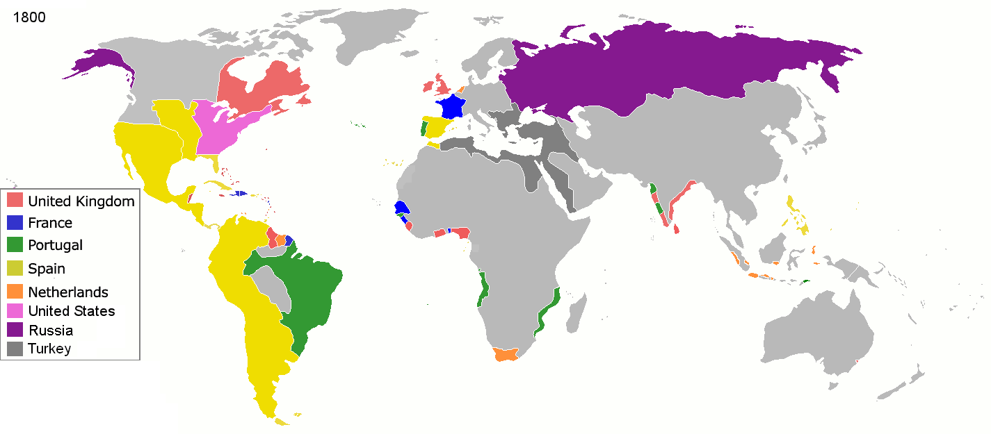
Laburpena
| Deskribapena |
English: Colonial empires in 1800 Français : Empires coloniaux en 1800 Español: Imperios coloniales en 1800 Português: Impérios Coloniais em 1800
United Kingdom
France
Portugal
Spain
Netherlands
United States
Russia
Turkey
|
||||||||||||||||
| Data | |||||||||||||||||
| Jatorria | Norberak egina | ||||||||||||||||
| Egilea | Jluisrs | ||||||||||||||||
| Lizentzia (Fitxategi hau berrerabiltzen) |
|
||||||||||||||||
.jpg)
._LOC_2001620596.jpg)

|
File:Colonial empires in 1800.svg fitxategi honen bektore bertsioa da. Hau rasterizatutako bertsioaren ordez erabili beharko litzateke hobea izatekotan.
File:Colonisation 1800.png → File:Colonial empires in 1800.svg
Grafiko bektorialei buruzko informazioa lortzeko, irakurri SVGra trantsizioa Commonsen. MediaWikiko SVG irudien inguruko laguntza teknikoa ere badago. |
 |
| Annotations | This image is annotated: View the annotations at Commons |
Fitxategiaren historia
Data/orduan klik egin fitxategiak orduan zuen itxura ikusteko.
| Data/Ordua | Iruditxoa | Neurriak | Erabiltzailea | Iruzkina | |
|---|---|---|---|---|---|
| oraingoa | 21:28, 1 maiatza 2016 | | 1.425 × 625 (42 KB) | Mega-light | Dominican Republic was a French colonia between 1795 and 1808 through Treaty of Basilea. |
| 21:21, 1 maiatza 2016 |  | 1.425 × 625 (42 KB) | Mega-light | Dominican Republic was a French colonia between 1795 and 1808. | |
| 01:55, 28 iraila 2014 |  | 1.425 × 625 (42 KB) | Leftcry | minor | |
| 07:48, 16 maiatza 2013 |  | 1.425 × 625 (40 KB) | Kraj35 | British settlement in Australia - Sydney and Parramatta. | |
| 05:30, 16 urtarrila 2012 |  | 1.425 × 625 (52 KB) | Quigley | cleaner legend | |
| 16:07, 29 apirila 2010 |  | 1.425 × 625 (49 KB) | Kieran4 | Border changes | |
| 16:06, 29 apirila 2010 |  | 1.425 × 625 (49 KB) | Kieran4 | Dutch claims in Indonesia were exaggerated and Cape Colony was too small. | |
| 16:06, 29 apirila 2010 |  | 1.425 × 625 (49 KB) | Kieran4 | Dutch claims in Indonesia were exaggerated and Cape Colony was too small. | |
| 18:50, 15 otsaila 2009 |  | 1.425 × 625 (49 KB) | EuroHistoryTeacher | lousiana was spanish in 1800, would be french officially in 1803 then sold to USA. no spanish settlement in western sahara, or spanish guinea. USA was not a colonisation power. | |
| 22:38, 21 urtarrila 2009 |  | 1.425 × 625 (49 KB) | TashkentFox | {{Information |Description= |Source= |Date= |Author= |Permission= |other_versions= }} |
Irudira dakarten loturak
Hurrengo orrialdeek dute fitxategi honetarako lotura:
Fitxategiaren erabilera orokorra
Hurrengo beste wikiek fitxategi hau darabilte:
- af.wikipedia.org proiektuan duen erabilera
- ast.wikipedia.org proiektuan duen erabilera
- av.wikipedia.org proiektuan duen erabilera
- az.wikipedia.org proiektuan duen erabilera
- ba.wikipedia.org proiektuan duen erabilera
- be.wikipedia.org proiektuan duen erabilera
- ca.wikipedia.org proiektuan duen erabilera
- ce.wikipedia.org proiektuan duen erabilera
- cs.wikipedia.org proiektuan duen erabilera
- da.wikipedia.org proiektuan duen erabilera
- en.wikipedia.org proiektuan duen erabilera
- eo.wikipedia.org proiektuan duen erabilera
- es.wikipedia.org proiektuan duen erabilera
- fi.wikipedia.org proiektuan duen erabilera
- fr.wikipedia.org proiektuan duen erabilera
- gl.wikipedia.org proiektuan duen erabilera
- ha.wikipedia.org proiektuan duen erabilera
- he.wikipedia.org proiektuan duen erabilera
- hy.wikipedia.org proiektuan duen erabilera
- id.wikipedia.org proiektuan duen erabilera
- io.wikipedia.org proiektuan duen erabilera
- it.wikipedia.org proiektuan duen erabilera
- ja.wikipedia.org proiektuan duen erabilera
- ka.wikipedia.org proiektuan duen erabilera
- ml.wikipedia.org proiektuan duen erabilera
Ikus fitxategi honen erabilpen global gehiago.