Fitxategi:Cerro Bayo volcanic complex.jpg
Ez dago bereizmen handiagorik.
Cerro_Bayo_volcanic_complex.jpg ((640 × 422 pixel, fitxategiaren tamaina: 76 KB, MIME mota: image/jpeg))
Fitxategi hau Wikimedia Commonsekoa da. Hango deskribapen orriko informazioa behean duzu. |
Laburpena
| Deskribapena |
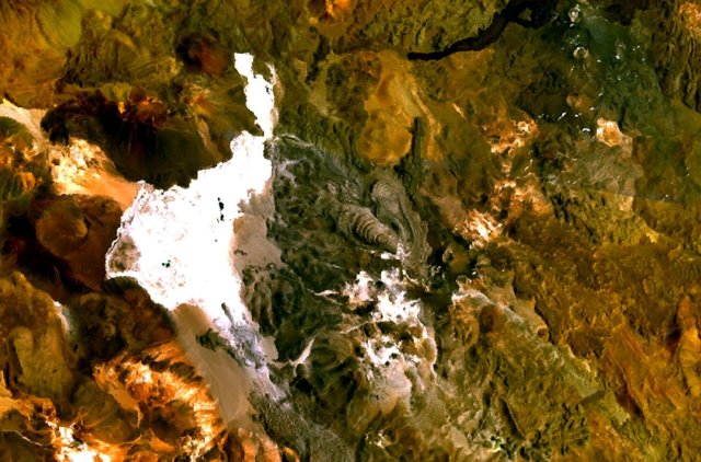
English: The Cerro Bayo volcanic complex lies along the Chile-Argentina border east of the Salar de Gorbea, the light-colored area at the left-center portion of this NASA Landsat image. A young well-preserved crater can be seen NE of an older snow-covered center (bottom-center). A younger northern center along the national border has a well-preserved 400-m-wide crater. The 5401-m-high summit of the Cerro Bayo complex, located west of the border in Chile, is the source of two viscous dacitic lava flows with prominent levees that traveled to the north. |
| Data | Data ezezaguna |
| Jatorria | http://www.volcano.si.edu/world/volcano.cfm?vnum=1505-122&volpage=photos&photo=115041 |
| Egilea | NASA Landsat7 image (worldwind.arc.nasa.gov) |
Lizentzia
| This image is in the public domain because it is a screenshot from NASA’s globe software World Wind using a public domain layer, such as Blue Marble, MODIS, Landsat, SRTM, USGS or GLOBE.
|
 |
Fitxategiaren historia
Data/orduan klik egin fitxategiak orduan zuen itxura ikusteko.
| Data/Ordua | Iruditxoa | Neurriak | Erabiltzailea | Iruzkina | |
|---|---|---|---|---|---|
| oraingoa | 11:43, 23 abuztua 2010 | | 640 × 422 (76 KB) | Michael Metzger | {{Information |Description={{en|1=The Cerro Bayo volcanic complex lies along the Chile-Argentina border east of the Salar de Gorbea, the light-colored area at the left-center portion of this NASA Landsat image. A young well-preserved crater can be seen NE |
Irudira dakarten loturak
Hurrengo orrialdeek dute fitxategi honetarako lotura:
Fitxategiaren erabilera orokorra
Hurrengo beste wikiek fitxategi hau darabilte:
- arz.wikipedia.org proiektuan duen erabilera
- de.wikipedia.org proiektuan duen erabilera
- en.wikipedia.org proiektuan duen erabilera
- eo.wikipedia.org proiektuan duen erabilera
- es.wikipedia.org proiektuan duen erabilera
- fa.wikipedia.org proiektuan duen erabilera
- fr.wikipedia.org proiektuan duen erabilera
- it.wikipedia.org proiektuan duen erabilera
- pt.wikipedia.org proiektuan duen erabilera
- ru.wikipedia.org proiektuan duen erabilera
- sv.wikipedia.org proiektuan duen erabilera
- uk.wikipedia.org proiektuan duen erabilera
- www.wikidata.org proiektuan duen erabilera